
Taiwan Central Weather Bureau forecaster Liu Yuqi pointed out this afternoon that Typhoon Kemi has slightly strengthened in intensity, showing characteristics of a double eyewall, and its impact on Taiwan will be most severe this evening and early on the 25th.
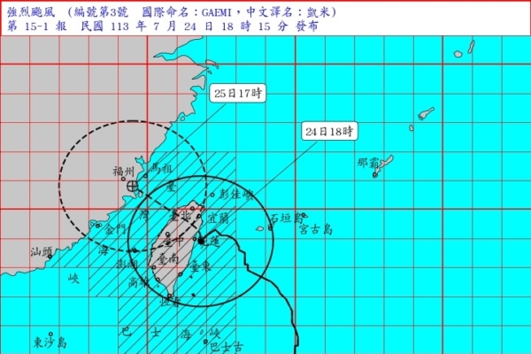
The Central Weather Bureau announced at 6:15 pm today that the center of the powerful Typhoon Kemi (internationally named GAEMI) at 6 pm was located at 23.9 degrees north latitude and 121.8 degrees east longitude, approximately 20 kilometers southeast of Hualien, moving northwest at a speed of 19 to 12 kilometers per hour.
Forecaster Liu Yuqi stated that by 2 pm, the typhoon’s wind circle had already covered most of Taiwan, and it is estimated to pass over the island from tonight until early on the 25th, with a possibility of erratic movements. Typhoon Kemi is expected to enter the northern Taiwan Strait on the morning of the 25th, which will be the period of most intense impact on Taiwan. Everyone is reminded to make typhoon preparations, stay vigilant, and closely monitor the typhoon’s development.
Liu Yuqi noted that Typhoon Kemi exhibits characteristics of a double eyewall (indicating rapid strengthening of the typhoon). In addition to being cautious of the strong winds and heavy rain from the eyewall, Yilan should also be prepared for the possibility of the typhoon veering slightly southward, bringing extremely strong winds and heavy rain to the Hualien area.
The Central Weather Bureau forecasted that from late this evening until the early hours of the 25th, Yilan and northern Hualien will experience strong winds and heavy rain near the center of the typhoon. Residents are advised to take precautions. The winds and rain will continue to intensify in various areas, so outdoor items, signs, fences, scaffolding, etc., should be securely fastened, and balcony decorations should be properly arranged.
The Central Weather Bureau further stated that coastal areas near Taiwan (including Green Island, Orchid Island), as well as Penghu, Kinmen, and Matsu, will experience significantly higher waves, with a risk of long waves occurring. Particularly, waves over 7 meters have been observed in the northeast coastal areas, while waves over 6 meters high are present in the northern Keelung coast, eastern region, Hengchun Peninsula, and north of Yunlin. It is recommended to avoid seaside activities. Given the high tide, the period of rising tide is not conducive to drainage, so low-lying coastal areas in the southwest, north coast, Yilan, and Taitung should be alert to the risk of seawater backflow and flooding.
A land strong wind warning has been issued by the Central Weather Bureau: due to the impact of the typhoon, coastal areas, open spaces, and outlying islands throughout Taiwan will experience noticeably strong winds. Yilan, Hualien coastal and open areas, Hengchun Peninsula, Green Island, Orchid Island will have gusts of 13 to 15 on the Beaufort scale. The western coastal and open areas, north coast of Keelung, and Penghu will have gusts of 10 to 12, while the coastal areas and open spaces of Taitung, Taipei City, and Matsu will have gusts of 9 to 10. Chiayi City, Nantou, and Kinmen will also experience gusts of 8 to 9, so extra caution is advised.
Regarding high temperatures in Taiwan, the Central Weather Bureau mentioned that due to the influence of the typhoon circulation descent, there is a probability of the occurrence of foehn winds in Hualien County. Therefore, today, Hualien County is under a yellow alert for hot weather.