
On September 22, 2025, Typhoon Huaqasha intensified to a severe typhoon on the morning of the 21st, as reported by the Central Weather Bureau. The typhoon is still showing signs of strengthening. Meteorological experts in Taiwan have pointed out that according to the European model simulations, from today (22nd) to the 24th, due to the interaction between the typhoon or its peripheral circulation and the terrain, the eastern half of Taiwan and the high mountain areas of Kaoping need to be on high alert for potentially devastating torrential rains. Taitung, Hengchun Peninsula, and coastal areas should also be wary of strong winds.
The Central Weather Bureau of Taiwan stated that as of 8 a.m. this morning, the center’s position was at 19.3 degrees north latitude and 123.1 degrees east longitude, moving west at a speed of 23 kilometers per hour. The central pressure is 900 hectopascals, with a maximum wind speed near the center of 58 meters per second, and maximum gusts of 73 meters per second. The radius of gale-force winds averages 320 kilometers (320 kilometers to the northwest, 340 kilometers to the northeast, 270 kilometers to the southwest, and 340 kilometers to the southeast), while the radius of storm-force winds averages 150 kilometers (140 kilometers to the northwest, 160 kilometers to the northeast, 140 kilometers to the southwest, and 160 kilometers to the southeast).
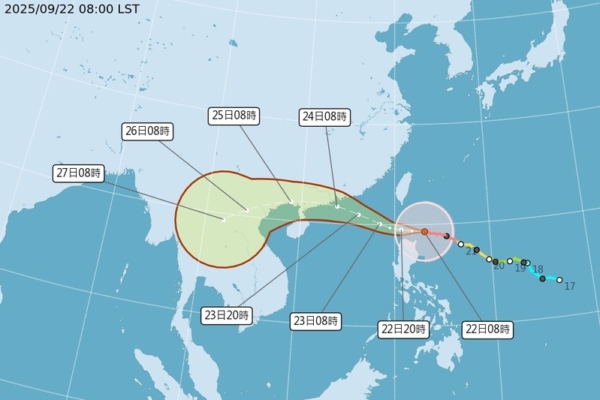
Wu Derong, associate professor at the Department of Atmospheric Sciences at National Central University in Taiwan, pointed out in the “Sky Machine Classroom” column of the Meteorological Applications Promotion Foundation that the latest European model (ECMWF) simulations on the evening of the 21st show that from today to the 24th, Typhoon Huaqasha will pass through the Bashi Channel and enter the South China Sea. The effects of the typhoon or its peripheral circulation combined with the terrain will result in significant rainfall in Greater Taipei, the eastern half, and southern parts of Taiwan. The eastern half and high mountain areas of Kaoping should be cautious of heavy rainfall that could lead to disasters, while Taitung, Hengchun Peninsula, and coastal areas need to guard against strong winds. Sea areas near Taiwan should also be prepared for strong winds and huge waves.
According to Wu Derong, the latest European model simulations suggest that on the 25th, Typhoon Huaqasha will move away, with lingering morning rain in Hualien and Kaohsiung before improving during the day with rising temperatures. From the 26th to the 28th, sunny and hot weather is expected across the region, with a chance of isolated brief showers or thunderstorms in mountainous areas in the afternoon and sporadic brief rainfall in the eastern half.
Wu Derong further mentioned that the latest European ensemble model simulations regarding Typhoon Huaqasha’s movement are similar to the Central Weather Bureau’s “Path Potential Prediction Chart” at 2 a.m. on the 22nd. Although individual simulation paths are spread on both sides, the ensemble simulations show relative convergence, indicating a reduction in “uncertainty.”
The Central Weather Bureau predicts that the average near-center wind speed of Typhoon Huaqasha, the “Wind King” of this year, reaches up to 60 meters per second. Due to its large size and strength, even if the typhoon’s center does not make landfall, the interaction between the typhoon and its peripheral circulation combined with the terrain will still pose a threat of strong winds and devastating heavy rains, which should not be underestimated.
Regarding the super typhoon Raccoon, regardless of various countries’ model simulations or the Central Weather Bureau’s “Path Potential Prediction Chart,” it remains far from Taiwan with no threat. The simulations of various countries also indicate that there is another tropical disturbance developing in the eastern seas of the Philippines this week. It is expected to pass through the Philippines and enter the South China Sea, with no impact on Taiwan.