
The Taiwan Central Weather Bureau announced today (23rd) that Tropical Storm Fan Gao, the seventh of the season, has formed and is expected to move towards the waters south of the Ryukyu Islands. Meteorological experts predict that on the 24th and 25th, the seasonal circulation and outer periphery of the storm will bring impact, leading to significant rainfall in northern Taiwan.
According to the Taiwan Central Weather Bureau, the tropical depression originally located east of the Philippines developed into Tropical Storm Fan Gao at 8 a.m., heading towards the waters south of the Ryukyu Islands.
Associate Professor Wu Derong from the Department of Atmospheric Sciences at National Central University stated in the “Weather Classroom” column of the Meteorology Application Promotion Foundation today (23rd) that the latest European model (ECMWF) simulation on the evening of the 22nd shows that the atmosphere remains unstable within the seasonal circulation, with the likelihood of localized brief showers on the east side of Greater Taipei and the eastern half of Taiwan, as well as the probability of afternoon showers or thunderstorms in mountainous areas of the western half, potentially expanding to some plain areas.
Wu Derong mentioned that the latest model simulations indicate that on the 24th and 25th, the seasonal circulation and the outer periphery of the storm will bring impact, resulting in significant rainfall in northern Taiwan accompanied by stronger gusts. There is also a probability of afternoon showers or thunderstorms in central and southern regions. From the 26th to the 29th, areas will still be affected by the seasonal circulation, with the atmosphere remaining unstable and the likelihood of localized showers throughout, vigorous convective activities in the afternoon, and the need to be cautious of localized “severe weather” events (lightning, strong winds, sudden heavy rainfall) occurring, with hot and humid weather in rain-free periods.
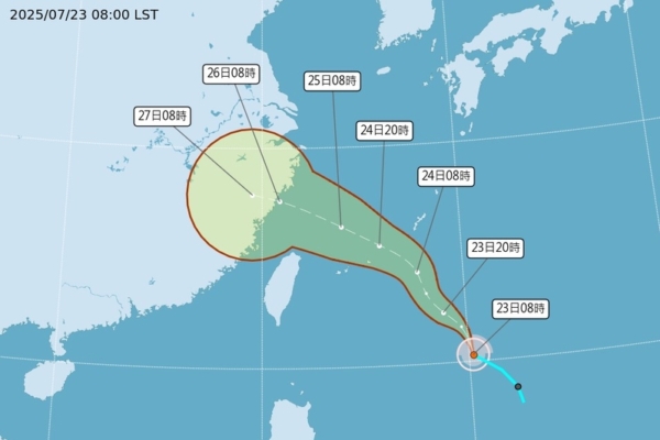
Wu Derong stated that the latest “Path Potential Prediction Map” from the meteorological bureau at 2 a.m. on the 23rd shows that Tropical Storm Fan Gao will form today. Consistent with the latest European model simulation, it will pass through the eastern waters of Taiwan and head towards the northern waters, but due to vertical wind shear restriction, it will only develop into a weaker tropical storm with a loose structure. Another tropical system in the waters north of Guam is expected to strengthen, but its main path, as simulated by models, will be further north and away from Taiwan, causing no impact on the region.