
On July 5, 2025, Typhoon Dana was formed in the early morning, with the Taiwan Central Weather Bureau issuing a maritime typhoon warning on the same day. Meteorological experts point out that Typhoon Dana is gradually approaching, posing a serious threat to Taiwan on the 6th and 7th.
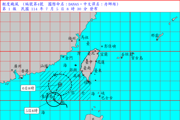
The Taiwan Central Weather Bureau stated that as of 8 a.m. today, the center of Typhoon Dana was located at 20.1 degrees north latitude and 117.4 degrees east longitude, about 410 kilometers southwest of Eluanbi, moving at a speed of 8 to 11 kilometers per hour in a north-northeast direction. The central pressure is 998 hectopascals, with a maximum wind speed near the center of 18 meters per second (about 65 kilometers per hour), equivalent to a grade 8 wind, and momentary maximum gusts of 25 meters per second (about 90 kilometers per hour), equivalent to a grade 10 wind. The average radius of gale-force winds is 80 kilometers (50 kilometers on the northwest side, 50 kilometers on the northeast side, 100 kilometers on the southwest side, and 100 kilometers on the southeast side).
Associate Professor Wu Derong of the Department of Atmospheric Sciences at Central University pointed out in the “Skynet Classroom” column of the Meteorological Applications Promotion Fund that the latest European model simulation at 8 p.m. on the 4th shows that the weather in northern Taiwan today will continue to be sunny and hot, so people should take precautions against sunburn and heatstroke.
Wu mentioned that the southern and eastern parts of Taiwan will see showers gradually increase in the afternoon due to the influence of Typhoon Dana’s peripheral moisture. The temperatures in various regions are expected to range from 24 to 37 degrees Celsius in the north, 22 to 36 degrees Celsius in the central region, 23 to 35 degrees Celsius in the south, and 22 to 35 degrees Celsius in the east.
According to Wu, the latest model simulation indicates that from the afternoon of the 6th to the 7th, the impact of Typhoon Dana will be most significant, with southern Taiwan bearing the brunt followed by the central region. The eastern part needs to guard against heavy rainfall, while the Penghu, Kinmen, and Matsu areas are directly threatened. People should pay attention to strong winds and heavy rain. The wind and rain are expected to gradually ease on the evening of the 7th. From the 8th to the 12th, the weather will improve with mostly sunny to partly cloudy skies and relatively hot temperatures. However, the atmosphere will remain unstable, with the likelihood of strong convection in the afternoons.
In the early morning at 2 a.m., the Meteorological Administration’s potential track prediction chart showed that Typhoon Dana, which was upgraded to a tropical storm, was formed in the southwest sea area of Taiwan Peninsula, moving slowly and gradually turning north-northeast. The intensity will gradually increase, and it is expected to enter the Taiwan Strait in its strongest form.
Wu added that on the 6th and 7th, as Typhoon Dana passes through the Taiwan Strait, the gale circle will sweep over parts of the western mainland and the Penghu, Kinmen, and Matsu areas. By the 8th, under the influence of the high pressure in the northeast direction, it will turn towards Zhejiang. People need to pay close attention to the warnings issued by the weather bureau and strengthen typhoon precautions. As for Tropical Storm Muen, it is currently in the southeast sea area of Japan, moving northeast before turning north-northwest and then north-northeast in an S-shaped path, moving away from Japan.
The latest European ensemble model simulation chart shows that the previously scattered model paths of Typhoon Dana have converged somewhat, with a slight shift to the west, passing through the Taiwan Strait. However, there are still some paths that indicate potential landfall in Taiwan. The probability map for gale force winds also shows that the possibility of passing through the Taiwan Strait is the highest, while the likelihood of landfall in Taiwan has decreased but cannot be completely ruled out. As the models are constantly being adjusted, it is important to continue monitoring the situation closely.