
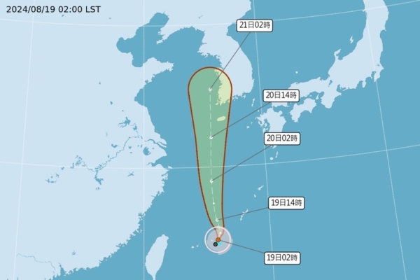
Taiwan’s Central Weather Bureau announced today (August 19) that the tropical depression located in the waters south of the Ryukyu Islands has developed into a mild typhoon named Lark at 2 a.m., moving towards South Korea without directly affecting Taiwan. Due to the strengthening southwestern wind, southern regions of Taiwan should be vigilant against heavy rain until the morning of the 20th, with a probability of heavy rain continuing in the central and southern areas during the daytime on the 20th.
The Central Weather Bureau released information on the typhoon formation. At 2 a.m. today, Typhoon Lark’s central pressure was 1,000 hPa, with the center located at 24.8 degrees north latitude and 125.8 degrees east longitude, about 260 kilometers southwest of the Ryukyu Islands, moving at a speed of 17 to 30 kilometers per hour in a north-northwesterly direction, with maximum winds near the center reaching 18 meters per second, equivalent to Beaufort scale 8 wind, and gusts up to 25 meters per second, equivalent to Beaufort scale 10 wind. The storm’s radius of 7-grade storm winds is 100 kilometers, and it is predicted that by 2 a.m. on the 20th, the center will be at 29 degrees north latitude and 125.5 degrees east longitude, about 390 kilometers northwest of the Ryukyu Islands.
The Central Weather Bureau stated that Typhoon Lark will move towards South Korea with no direct impact on Taiwan. Due to the effects of the low-pressure zone and the strengthening southwestern wind until the morning of the 20th, brief showers or thunderstorms are expected in the central and southern regions of Taiwan, as well as in the Penghu, Kinmen, and Matsu Islands, with a high possibility of local heavy rain, particularly in the southern regions where brief heavy rain may occur. Other areas will be mostly cloudy, with a chance of brief thunderstorms in the afternoon, and a probability of heavy rain. Scattered brief showers are also expected in the northern regions in the early morning.
The Central Weather Bureau further mentioned that starting from the daytime on the 20th, brief showers or thunderstorms will continue in the central and southern regions of Taiwan, including the Penghu, Kinmen, and Matsu Islands, with a continued chance of heavy rain in these areas. Other regions will be mostly cloudy, with local brief thunderstorms in the northern and northeastern areas, as well as other mountainous regions in the afternoon, with a possibility of heavy rain. Coastal areas from Taoyuan to Changhua and the Hengchun Peninsula, as well as Lanyu, Green Island, and Matsu, may experience strong gusts of 8 to 9 Beaufort scale. There is also a probability of hail in the southeastern regions on the 20th.
Associate Professor Wu Derong of the Department of Atmospheric Sciences at National Central University spoke on the show “Meteorological Revelation” on SET TV today, expressing that the latest European model (ECMWF) simulation from 8 p.m. on the 18th shows that the large low-pressure circulation on the 19th and 20th, along with the gradual dissipation of Typhoon Lark moving northward off the eastern coast of Taiwan. However, the southwestern monsoon will still pass through Taiwan, leading to a chance of localized heavy thunderstorms due to the terrain-induced uplift, requiring continued vigilance against severe weather such as lightning, strong winds, and sudden heavy rain.
Professor Wu mentioned that the latest simulations indicate a strengthening of the Pacific high-pressure system from the 21st to the 25th, resulting in clear and hot weather across the island that requires sun protection and prevention of heatstroke. There might be occasional brief thunderstorms in the mountains in the afternoons of the 21st, affecting some flatland areas. On the 22nd and 23rd, localized brief thunderstorms are expected to be confined to the mountainous regions. From the 24th to the 25th, localized afternoon thunderstorms may occur, slightly more widespread, mainly in the mountainous areas with some impact on certain flatland areas.