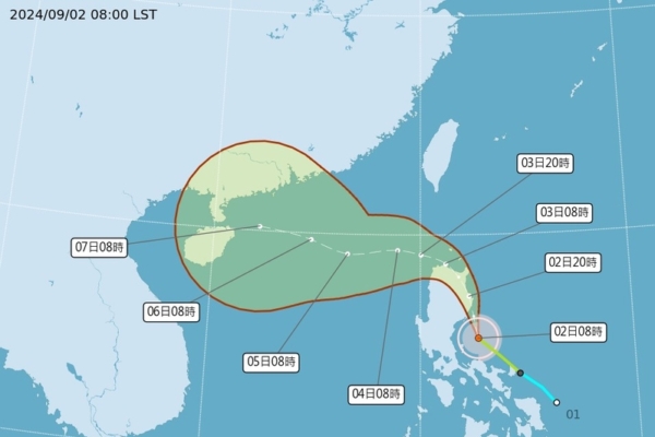
Taiwan’s Central Weather Bureau announced on the evening of the 1st that Typhoon “Capricorn” had formed, but whether it would affect Taiwan still needed further observation.
The Central Weather Bureau indicated that as of 8 a.m. on the 2nd, the center of the typhoon was located at 15.3 degrees north latitude and 122.7 degrees east longitude, moving at a speed of 19 kilometers per hour in a north-northwesterly direction. The central pressure was 995 hPa, the maximum wind speed near the center was 20 meters per second, and the maximum instantaneous gust was 28 meters per second. The radius of strong winds extended up to 100 kilometers (80 kilometers on the northwest side, 120 kilometers on the northeast side, 80 kilometers on the southwest side, 120 kilometers on the southeast side). Vessels in the Bashi Channel and nearby waters of the Philippines should pay special attention and keep track of the latest developments of this typhoon.
Associate Professor Wu Derong from the Department of Atmospheric Sciences at National Central University in Taiwan mentioned on a weather program that Typhoon Capricorn formed on the evening of the 1st at 8 p.m. According to the Central Weather Bureau’s “path potential forecast map” at 2 a.m. today, the typhoon was expected to move north-northwesterly, eventually turning west after passing the northern tip of Luzon and entering the South China Sea. The trajectory’s uncertainty still had the typhoon at a distance but not far from Taiwan, undergoing slow strengthening over the first three days due to land constraints and potentially reaching moderate intensity after moving into the South China Sea.
Wu pointed out that the latest data from the European Centre for Medium-Range Weather Forecasts (ECMWF) model at 8 p.m. on the 1st showed that the probability of Taiwan being directly impacted by strong winds had decreased to below 20%. However, as modeling continued to adjust, the impact could still change, necessitating ongoing close monitoring.
The Central Weather Bureau noted significant discrepancies in various countries’ predictions regarding the path of Typhoon Capricorn, attributed to factors such as fluctuations in the strength of the Pacific high-pressure system, the typhoon’s interactions with the Philippine landmass, and other influences. Further observation was required to determine the actual path and potential impact on Taiwan.
Starting from the 3rd, the peripheral circulation of the typhoon was expected to bring localized brief showers to areas including Keelung’s northern coast, Greater Taipei, the eastern regions, and the Hengchun Peninsula in Taiwan. Moderate to strong gusts were also forecasted for coastal areas from Taoyuan to Taichung and the Hengchun Peninsula on the 3rd.
The Central Weather Bureau issued a special strong wind warning for maritime areas, as the typhoon’s outer circulation was set to increase the average wind force to Beaufort scale 6 in the northern waters and southeastern sea areas of Taiwan from the afternoon of the 3rd, accompanied by maximum storm gusts of 8 to 9 levels. Mariners were advised to exercise caution.
Due to the influence of the typhoon’s outer circulation and southwest winds, the average wind force was projected to rise to Beaufort scale 6 from this afternoon to tonight in the Bashi Strait and Nansha Islands seas, with maximum gusts reaching level 9. By morning on the 3rd, the wind force in the Bashi Strait was anticipated to intensify to levels 8 to 9, with peak gusts reaching level 11. From the afternoon to night on the 3rd, the average wind force in the Dongsha Islands and the Zhongsha Islands seas was expected to increase to Beaufort scale 6, while maritime areas in southern parts of the Yellow Sea could experience winds up to level 6. Wind conditions in the southern part of the Yellow Sea were expected to slightly weaken today.
The Central Weather Bureau forecasted mostly sunny to partly cloudy weather across Taiwan, Penghu, Kinmen, and Matsu on both today and the 3rd. However, there was a probability of temperatures exceeding 37 degrees Celsius in Greater Taipei, Taoyuan, and Hsinchu. In addition, localized brief thunderstorms were expected in the afternoon in central and southern regions, with a chance of heavy rain in areas south of Chiayi. On the night of the 2nd to the daytime of the 3rd, sporadic short showers were expected along Keelung’s northern coast, eastern regions, the Hengchun Peninsula, and central and southern Taiwan.
The Central Weather Bureau reiterated the impact of the typhoon’s outer circulation from the 3rd, with localized brief showers forecast for Keelung’s northern coast, Greater Taipei, the eastern regions, and the Hengchun Peninsula. Strong gusts were anticipated for coastal areas from Taoyuan to Taichung and the Hengchun Peninsula on the 3rd.

