
Taiwanese meteorologists have indicated that Tropical Storm Bualo formed in the early hours of today (September 24), and is predicted to pass through the Philippines before heading roughly towards Hainan Island, with no direct impact expected on Taiwan. The outskirts of Typhoon Huanjasha and the interaction between terrain are still causing rain in the eastern and southern parts of Taiwan, with the mountainous areas in eastern Taiwan being on alert for heavy rainfall.
The Central Weather Bureau of Taiwan issued a typhoon formation notice today, stating that the tropical depression which was originally located southeast of the Philippines sea had developed into a mild typhoon at 2 a.m. today, designated as Typhoon Bualo (international name: Bualo). It is expected to move northwestwards towards the Philippines and has no direct influence on Taiwan.
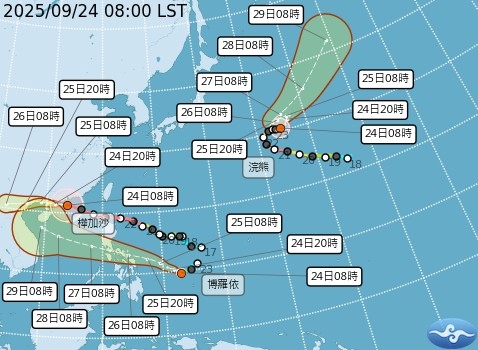
Associate Professor Wu Derong from the Department of Atmospheric Sciences at National Central University of Taiwan, mentioned in the “Heavenly Mechanism Classroom” column of the Meteorological Applications Promotion Foundation today, that according to the latest Central Weather Bureau’s path potential forecast, Typhoon Huanjasha is expected to make landfall between the Pearl River Delta and the Leizhou Peninsula this afternoon to evening. Due to its slow weakening intensity, it poses a significant threat to Hong Kong, Macau, and the Pearl River Delta region, while Typhoon Raccoon remains distant from Taiwan, posing no threat.
Wu Derong further expressed that another tropical depression had developed into the 20th typhoon of the year, Bualo, at 2 a.m. today. Its trajectory, as per the latest European ensemble model simulation, is similar and is expected to pass through the Philippines towards Hainan Island with no impact on Taiwan.
He added that the latest European model simulation shows that by today, Typhoon Huanjasha will enter the Guangdong Sea, with Taiwan still experiencing rain due to the outer circulation of the typhoon and interaction with terrain. The eastern and southern parts will continue to receive rain, with the mountainous areas in eastern Taiwan facing a risk of landslides, falling rocks, and debris flow. Meanwhile, the north will transition to clear and hot weather, with the highest temperature reaching 38 degrees Celsius.
Furthermore, Wu Derong mentioned that according to the latest European model simulation, starting from the 25th, the Pacific high pressure will extend westward, resulting in mostly clear and stable weather for the upcoming week. Tomorrow will be sunny and hot across the island, with temperatures rising above 38 degrees Celsius. On the 26th and 27th, the sunny and hot weather will persist, cautioning against sun exposure and heatstroke prevention, with sporadic scattered showers possible in the afternoons at mountainous areas and the eastern part. From the 28th to the 30th, the weather will remain sunny and hot across the island, with the possibility of isolated short showers or thunderstorms in mountain areas during the afternoons.