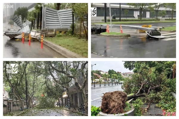
On the morning of September 16, Typhoon “Beibei Jia” made landfall along the coast from Pudong to Fengxian in Shanghai, with winds reaching the level of a strong typhoon, at 14 on the Beaufort scale, equivalent to 42-45 meters per second. This marked the strongest typhoon to hit Shanghai since 1949.
According to reports from mainland Chinese media, heavy rain poured down across various regions of Shanghai from the morning onwards. Trees along the streets swayed violently in the strong winds, making it almost impossible for pedestrians to stay steady. Construction site corrugated iron fences were blown away, and electric poles and roadside trees were uprooted. Residents in areas such as Kunshan, Pudong, and Hongqiao reported power outages.
A reporter from mainland China witnessed the intense rainfall near Dishing Lake in Pudong, Shanghai, with the scene in front of the camera filled with a blanket of white.
Due to the impact of Typhoon “Beibei Jia”, from 8:00 am on September 16 to 8:00 am on September 17, certain regions of Anhui, Jiangsu, Shanghai, Zhejiang, and other areas experienced heavy to torrential rain. Specifically, parts of central-eastern Anhui, southern Jiangsu, and northern Zhejiang saw heavy downpours.
Warnings were issued for regions including Shanghai and its coastal areas, southeastern Jiangsu and its coastal areas, northeastern Zhejiang and its coastal areas, the Hangzhou Bay, the area around the mouth of the Yangtze River, and the Zhoushan Islands, with wind speeds ranging from 9 to 11 on the Beaufort scale and gusts reaching 12 to 13. In the vicinity where the center of “Beibei Jia” passed, winds could reach levels of 12 to 14, with gusts of 15 to 16.
On September 16 at 18:00, the China Meteorological Administration issued a yellow typhoon warning for “Beibei Jia”. The center of the typhoon had moved from Qingpu in Shanghai to Kunshan in Jiangsu around 11:30 am on the 16th. By 3:00 pm that afternoon, “Beibei Jia” had weakened to a strong tropical storm level within the territory of Wuxi, Jiangsu. At 5:00 pm, its center was still located in Wuxi, Jiangsu, at approximately 31.5 degrees north latitude and 119.9 degrees east longitude. The maximum wind force in the vicinity of the center was at level 11 (30 meters per second), with the lowest central pressure recorded at 978 hPa.
It is expected that “Beibei Jia” will continue to move west-northwestward at a speed of 15 to 20 kilometers per hour, gradually weakening in intensity. By the early hours of September 17, it is forecasted to move into Anhui, classified as a tropical storm, with wind speeds of 8 to 9 on the Beaufort scale, equivalent to 20-23 meters per second, before entering Henan on the night of the 17th as a tropical depression, with wind speeds of 6 to 7, or 13-15 meters per second.

