
Taiwan’s Central Weather Bureau announced this morning that Typhoon Peipah had developed into a mild typhoon at 2 a.m. It is predicted to move towards Japan in the coming days, posing no threat to Taiwan.
The Central Weather Bureau of Taiwan released information on the formation of the typhoon this morning. The tropical depression, originally located south of Kyushu, Japan, has developed into a mild typhoon named Peipah (international name: PEIPAH) at 2 a.m. today. It is forecasted to move towards Kyushu and Shikoku in Japan, with no impact expected on Taiwan.
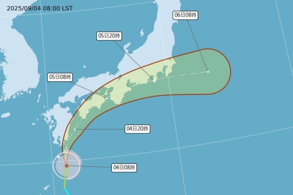
According to the Central Weather Bureau, the center of Typhoon Peipah was located at 29.7 degrees north latitude, 131.1 degrees east longitude at 8 a.m. today. It is moving north at a speed of 24 kilometers per hour. The central pressure is 1,000 hPa, with maximum sustained winds near the center at 18 meters per second and maximum gusts of 25 meters per second. The radius of gale-force winds extends up to 100 kilometers from the center (80 kilometers on the northwest side, 120 kilometers on the northeast side, 80 kilometers on the southwest side, and 110 kilometers on the southeast side).
Dr. Wu Derong, an associate professor at the Department of Atmospheric Sciences at National Central University, mentioned in the program “Sanli’s Accurate Meteorology & Older Leaks of Heavenly Secrets” today that according to the latest European (ECMWF) model simulation as of 8 p.m. on the 3rd, the weather across Taiwan is expected to be partly cloudy, with lingering heat. Convective development is anticipated in mountainous areas in the afternoon, spreading to some plains, so attention should be paid to the occurrence of local heavy thunderstorms (accompanied by lightning, strong winds, sudden heavy rain, hail, etc.).
Dr. Wu further stated that the latest European model simulation indicates clear weather in various areas on the 5th and 6th, with extreme heat in the north reaching temperatures of 37 to 38 degrees Celsius. UV levels will be at dangerous levels around noon, so sun protection and prevention of heatstroke are advised. In the afternoon, there may be isolated showers or thunderstorms in mountainous areas, with a chance of brief rainfall in the south and southeast.
From the 8th to the 11th, Dr. Wu predicted increased moisture in the south, with partly cloudy skies across the island, and continued warm weather in northern Taiwan. There may be brief local showers in the south and southeast, with convective development in mountainous areas in the afternoon, extending to some plains, highlighting the likelihood of heavy thunderstorms.
Furthermore, Dr. Wu mentioned that the “Path Potential Prediction Map” issued by the Central Weather Bureau at 2 a.m. today showed that the tropical depression had developed into a mild typhoon Peipah in the seas east of the Ryukyu Islands, moving north and then making a sharp turn to the east. It is expected to affect Kyushu today and then Shikoku and the southern side of Honshu on the 5th. Travelers in Japan should be aware of its trajectory.
Dr. Wu also noted that according to the latest European ensemble model, the simulated average path of Typhoon Peipah is similar to the predicted path by the Central Weather Bureau. However, individual ensemble members have paths distributed on both sides of the average, indicating uncertainty, but without posing a threat to Taiwan.