
The Taiwan Central Weather Bureau stated that Tropical Storm Vipa, a mild storm, came closest to Taiwan today (July 19), with the most significant rainfall in the eastern half of the island. Meteorological experts indicated that over the next two days, Vipa would pass through the Bashi Channel, bringing localized showers to the western part of Taiwan, while the eastern regions and Pingtung would experience heavy rainfall.
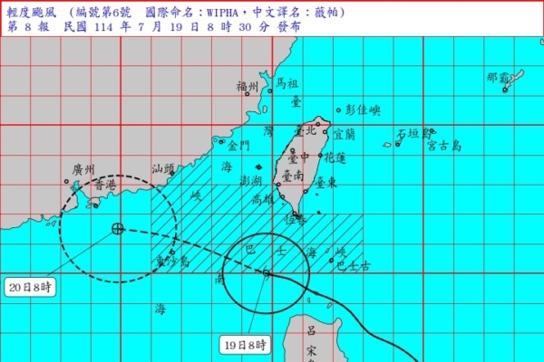
According to the Taiwan Central Weather Bureau, as of 8 a.m. today, the center of Tropical Storm Vipa was located approximately 240 kilometers south-southwest of Eluanbi, with a central pressure of 980 hPa. The maximum wind speed near the center reached 28 meters per second, equivalent to a level 10 wind, with gusts reaching up to 35 meters per second, akin to a level 12 wind. The storm’s radius of gale-force winds extended 150 kilometers, moving at a speed of 24 kilometers per hour in a west-northwesterly direction, later turning west.
Wu Derong, an associate professor in the Department of Atmospheric Science at National Central University in Taiwan, in his column “Sky Machine Classroom” under the Meteorological Application Promotion Foundation, pointed out that the latest European model (ECMWF) simulation from 8 p.m. on the 18th indicated that over the next two days, Tropical Storm Vipa would pass through the Bashi Channel and enter the South China Sea. This would bring localized showers to the western part of Taiwan and heavy rainfall to the eastern regions and Pingtung. Winds would strengthen across various areas, with stronger gusts along the coasts and in mountainous regions, requiring caution.
Wu Derong mentioned that the latest model simulations indicated that the weather next week would be influenced by the “monsoon low-pressure system,” which would bring a significant amount of moisture. Additionally, the development and movement of another “tropical system” within that system were crucial factors. He emphasized the high level of uncertainty due to ongoing model adjustments, stressing the need for close monitoring of the situation.
Furthermore, Wu Derong highlighted that the most recent “Path Potential Prediction Map” from the Bureau at 2 a.m. on the 19th and the latest European ensemble model (ECMWF) from 8 p.m. on the 18th both indicated that from the 19th to the 23rd, Tropical Storm Vipa’s center would pass through the Bashi Channel and enter the South China Sea before making landfall in Guangdong.
In addition, he mentioned that various international models suggested the development of another “tropical system” within the “monsoon low-pressure system” next week, with some simulations showing threatening potential paths. Out of 50 simulations from the European ensemble model, the highest probability was for the storm to turn northward from the east of Taiwan, with a slightly reduced 40% chance of Northern Taiwan being directly hit by the storm. The models from different countries continue to adjust, underscoring the importance of vigilant monitoring.