
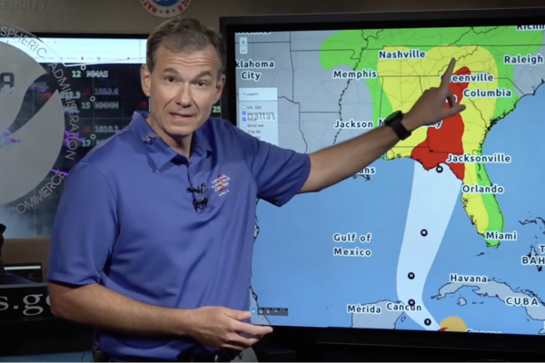
The U.S. National Hurricane Center (NHC) predicted that tropical storm “Helene” formed in the Caribbean on Tuesday morning, September 24 and will move northward. By Thursday night, September 26, it is expected to intensify into a Category 3 hurricane and make landfall in Florida.
According to the Orlando Sentinel, the NHC issued a hurricane warning for the Gulf Coast area of Florida, anticipating landfall near the Big Bend region with waves reaching up to 15 feet.
As of the 11 a.m. update, the center of tropical storm “Helene” was located in the northwestern Caribbean Sea, approximately 180 miles southeast of Cozumel, Mexico, with maximum sustained winds of 45 mph and moving northwest at 12 mph.
The NHC predicts that on Wednesday, “Helene” will become a hurricane in the Gulf of Mexico and as it traverses the eastern Gulf, its wind strength will rapidly increase.
Jaime Rhome, deputy director of the NHC, stated that it will be a large storm in terms of its scale, potentially affecting a significant area of Florida, including densely populated areas like the I-4 corridor passing through Tampa and Orlando.
Rhome emphasized that indications point to the Big Bend area of Florida being impacted significantly, with a wind field larger than that of traditional hurricanes, potentially resulting in extensive storm surge on the western part of the Florida peninsula.
Florida Governor Ron DeSantis declared a state of emergency for 61 out of the 67 counties in Florida on Tuesday. He urged residents to prepare by filling up on fuel, stocking up on water and non-perishable food, clearing potential debris from yards, and being informed about evacuation zones.
Over 18,000 utility workers are prepared to address power outages caused by the hurricane, along with 3,000 National Guard soldiers and Florida Guard personnel ready for disaster response.
The Florida government has access to SpaceX’s Starlink network hardware for deployment as needed, along with new flood protection equipment to safeguard utility substations.
Kevin Guthrie, director of the Florida Division of Emergency Management, stated that due to the storm’s immense scale, county-level disaster warnings have been expanded across Florida.
DeSantis stressed the importance of heeding local evacuation orders to prevent a tragedy like the one caused by Category 5 Hurricane “Ian” in 2022, where 149 people lost their lives, many of whom were caught in massive waves in the southwest region.
The scope of this storm is vast, and most of Florida may experience strong winds and potential tornadoes starting from Wednesday night onward. “Helene” is expected to maintain its Category 3 hurricane intensity based on current projections.
For Florida, the likelihood of heavy rainfall and increased winds is expected to rise from Wednesday night through Friday. Parts of Florida and the southeastern U.S. could see rainfall amounts ranging from 4 to 8 inches, with localized areas potentially receiving up to 12 inches. Post-hurricane weekend, additional rainfall is expected across the Florida peninsula, leading to possible flooding in certain regions.