
In an era of advanced information technology, where people are accustomed to relying on smartphones to check maps and use navigation systems while traveling, Taiwan’s National Palace Museum raised a question: “How did ancient people orient themselves and reach their destination without modern technology?” In September, the museum launched a new exhibition featuring selected ancient maps from rare books, titled “Four Corners – Ancient Road and Mileage Maps Exhibition,” showcasing a diverse world of ancient maps.
According to the National Palace Museum in Taiwan, “Dao Li” is a term combining roads and mileage. The exhibition displays ancient maps depicting roads along with their corresponding mileages, as well as ancient books containing maps of roads and mileages.
While ancient maps may not offer the convenience of real-time electronic maps found in today’s navigation systems, they are rich in diverse forms. For example, there are route guides and distance maps in commercial books, detailed round-trip maps for imperial outings and tomb visits, border defense maps used by soldiers guarding frontiers, large-scale postal road maps connecting different regions, and city route maps included in regional administrative maps.
This exhibition is planned in two phases, each lasting approximately three months. The first phase includes sections such as “Postal Road Panorama,” “North-South Thoroughfare,” “Qing Emperor’s Tomb Visit,” “Traveling Across the World,” and “Citizens’ Boulevard.” The second phase remains unchanged in structure, with adjustments to focus on “Border Patrol Routes,” “Crossing Mountains and Rivers,” and “Southern Expedition Routes.”
The National Palace Museum in Taiwan stated that the exhibition covers map materials from the late 14th century to the early 20th century. The highlight of the exhibition is the “Taiwan Map with the Penghu Islands,” which, like the museum’s treasure, the “Kangxi Taiwan Yutu,” and other ancient maps of Taiwan, features a dotted line starting from Sama Rock Head (modern-day Mabidou Head) and extending northwards to near Dabaoli Society Ferry, representing the main north-south transportation artery in Taiwan since the 17th century – the North-South Thoroughfare.
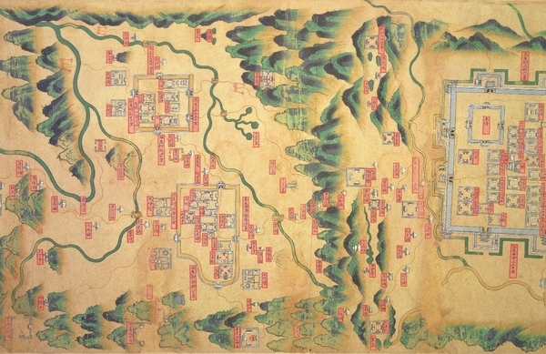
One of the featured pieces in the “Postal Road Panorama” section is the “Taiyuan to Gansu Postal Inn Map,” depicting the main and branch postal routes from Taiyuan Prefecture in Shanxi Province northwards to Datong Prefecture’s city and further north along the southern wall towards Tianchengwei City, eastwards to Dongshengwei City, and westwards to Dongshengwei City. The map, vividly colored with yellow solid lines representing postal routes, is a significant exhibit combining utility and aesthetic value.
Curator Lu Xueyan explained that to bridge the past and present and enhance audience engagement, the exhibition includes a special multimedia interactive installation titled “Walking on Taiwan’s Roads,” incorporating aerial video footage of transportation routes from Hsinchu to the museum using the “Kangxi Taiwan Yutu” and “Qianlong Taiwan Map” as references, providing visitors with a realistic experience of walking along the ancient north-south roads in Taiwan.
Moreover, the interactive area “Taiwan is My Home” outside the exhibition hall utilizes the “Taiwan Map with the Penghu Islands” as its foundation, marking representative local specialties on the map to guide viewers in identifying their hometowns. Furthermore, visitors can scan QR codes to fill out feedback forms, with the museum regularly publishing the results on its official website to enhance the resonance between the audience and the exhibition.