
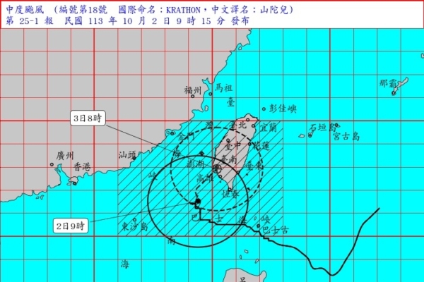
Taiwan’s Central Weather Bureau announced today that Typhoon Santao has weakened to a moderate typhoon, with its center located approximately 160 kilometers southwest of Kaohsiung at 9 a.m., moving in a northeast direction with a tendency to continue weakening. The estimated time of landfall has been postponed to the early morning of the 3rd.
According to the latest data, Typhoon Santao stayed nearly stationary in the past 3 hours. The center is currently over the sea southwest of Kaohsiung, moving in a north-northeast to east-northeast direction, with its wind circle affecting southern and eastern Taiwan, posing a threat to areas south of Taichung, Nantou, Hualien, Taitung, and Penghu. The typhoon is expected to continue weakening in intensity.
Land warning areas include Taichung, Changhua, Nantou, Yunlin, Chiayi, Tainan, Kaohsiung, Pingtung, Hengchun Peninsula, Hualien, Taitung, and Penghu should be on high alert.
Maritime warning areas include the Taiwan Strait, the eastern sea of Taiwan, the Bashi Channel, and the sea area near the Dongsha Islands. Ships navigating and operating in these areas should exercise caution.
The Central Weather Bureau of Taiwan stated that coastal areas and outlying islands near Taiwan are experiencing significant waves and long swells. High waves of 8 to 10 meters are expected in the southwest coastal areas and Hengchun Peninsula, while areas north of central Taiwan, eastern Taiwan, and Penghu may experience waves of over 5 meters. Activities near the sea should be avoided.
Strong wind warnings have been issued for various regions, with wind speeds gradually increasing. Southern Taiwn, Taoyuan to Chiayi, coastal areas of Taitung, Hengchun Peninsula, Orchid Island, Green Island, Penghu, Kinmen, and Matsu may experience gusts of 11 to 13 on the Beaufort scale.
The Central Weather Bureau warned residents of the southwest coastal areas of Taiwan to beware of storm surges and backflooding. Pingtung, Kaohsiung, Tainan, and Chiayi were advised to be vigilant against destructive gusts and short-duration heavy rainfall. Objects outdoors, signboards, fences, and scaffolding should be secured properly, and balcony plants should be placed securely.
Wu Derong, a visiting associate professor of atmospheric sciences at National Central University in Taiwan, pointed out that Typhoon Santao in the sea southwest of Taiwan has slightly weakened to a “moderate” intensity. As it slowly moves to the northeast, the typhoon center is expected to make landfall near Ji’an, with the landing time postponed to the early morning of the 3rd.
Due to Taiwan blocking the convergence of moisture and the frictional effect of landforms, the intensity of Typhoon Santao continues to weaken. Although the threat to the landing point has slightly diminished, it is still considered a moderate typhoon, accompanied by destructive gusts and intense rainfall. Even after landfall, while rapidly weakening to a tropical storm, there is still a threat of strong winds and heavy rains within the circulation. The predicted path still has uncertainties.
Based on the projected path by the Central Weather Bureau, gusty winds will gradually expand from south to north today. The typhoon’s center is expected to make landfall near Ji’an in the early morning of the 3rd, with its intensity continuing to weaken. After landfall, Santao will quickly weaken to a tropical storm due to terrain interference, but precautions against strong winds and heavy rain should still be taken. From the 4th onwards, the typhoon will continue to weaken, and the threat will gradually diminish.