
Taiwanese meteorologist Wu Derong stated that there will be a possibility of a tropical disturbance developing to the north of Guam around the 3rd and to the east of the Philippines around the 4th. However, there are discrepancies in the simulated locations and paths, so continued observation is recommended.
In his “Heaven’s Machine Classroom” column on the Meteorological Applications Promotion Foundation, Wu Derong, an adjunct associate professor at the Department of Atmospheric Sciences at National Central University in Taiwan, mentioned that according to the latest European model (ECMWF) simulation as of 8 p.m. on the 30th, today (1st) will be “as hot as midsummer,” with clear and scorching weather in various regions, and temperatures reaching over 37 degrees Celsius. Sun protection and heatstroke prevention should be taken seriously.
Additionally, he mentioned that there might be localized brief showers or thunderstorms in mountainous areas in the afternoon. There is also a chance of brief rainfall in the Hengchun Peninsula. Temperatures across different regions are expected to be between 24 and 38 degrees Celsius in the north, 24 to 37 degrees Celsius in the central region, 25 to 37 degrees Celsius in the south, and 22 to 37 degrees Celsius in the east.
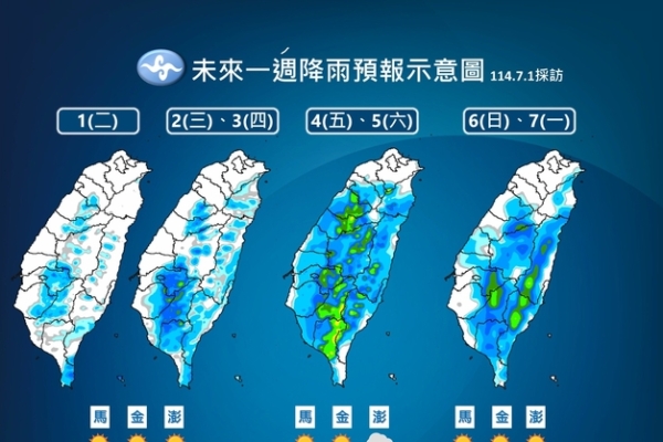
Wu Derong pointed out that according to the latest model simulation, from the 2nd to the 7th, there will be clear skies in various regions with afternoon clouds, localized brief showers or thunderstorms in mountainous areas in the afternoon, and a chance of extending to neighboring flatlands. The Hengchun Peninsula might also experience brief rainfall. Although the high temperatures will slightly decrease, it will still be hot in all regions with strong UV radiation, so sun protection and heatstroke prevention are necessary.
Wu Derong stated that based on the latest European model simulation, a tropical disturbance is brewing this week to the east of the Philippines and near Guam. Around the 3rd, a “mild typhoon” is expected to develop to the north of Guam and move away to the northeast. On the 4th, another “mild typhoon” is expected to develop to the east of the Philippines, also moving away to the northeast initially before turning back towards the vicinity of the Ryukyu Islands.
He mentioned that the latest European ensemble model simulation on the 6th shows the presence of a “mild typhoon” with a low probability extending from the southeast seas of Japan to near Taiwan, with the simulated positions differing greatly. The highest probability is only around 30%, mainly concentrated in the southeast seas of Japan and the southern seas of the Ryukyu Islands. The latest American ensemble model (GEFS) still shows discrepancies in the simulated path of the “mild typhoon” to the east of the Philippines, resembling scattered flowers in the sky. As the models from various countries will continue to adjust, ongoing observation is crucial.