
The East Coast and Southwest of the United States are forecasted to face severe weather conditions over the weekend, extending into the early part of next week. Coastal areas from North Carolina to New Jersey have already issued warnings and alerts.
A coastal storm named “Nor’easter” is forming in the southeastern coastal region of the United States, expected to bring tropical storm-level gusts, heavy rain, and flooding to most parts of the East Coast over the weekend and into early next week.
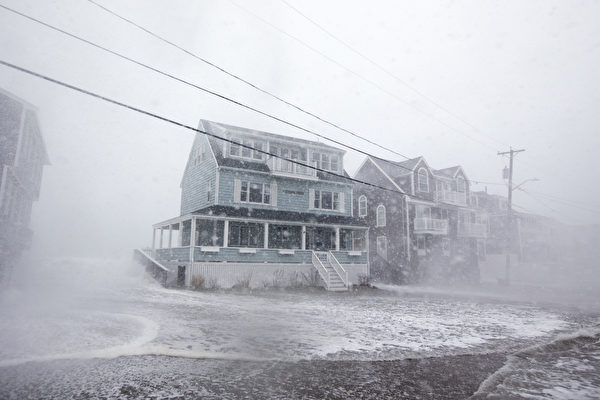
The National Weather Service warned on Friday, October 10th that the Nor’easter will have significant impacts on the eastern coastal region and could result in “disastrous” conditions, with coastal areas experiencing flooding, towering waves, seasonal high tides, dangerous rip currents, and strong gusts.
On Sunday and Monday, the destructive weather will further extend north, with other areas along the mid-Atlantic coast and southern New England possibly seeing several inches of rainfall. Multiple rounds of heavy rain could lead to localized flooding in affected regions.
The hardest-hit areas are expected to be located north of North Carolina. Major flight hubs like Washington D.C., New York City, and Boston may experience flight delays and cancellations due to strong winds.
Starting from Saturday, areas near the coast of North Carolina could see rainfall amounts of up to half a foot (about 1.8 meters), accompanied by gusts reaching up to 45 miles per hour. The Nor’easter is also set to intensify beach erosion in the Outer Banks. Since September 30th, at least nine uninhabited houses have collapsed and sunk into the Atlantic due to the recent storm-induced high waves and erosion.
Various warnings and alerts related to the Nor’easter have already been issued for coastal areas from North Carolina to New Jersey.
Meteorologist Matt Lanza from Houston warns that the threat of the Nor’easter is increasing, posing significant impacts on the mid-Atlantic region and northern New England.
Meteorologists also mentioned that the Nor’easter will interact with another storm moving southeast from the Great Lakes region. In the southeast, the Nor’easter could bring up to 6 inches of rain to local areas on Florida’s east coast and up to 4 inches of rain to the Outer Banks of North Carolina.
Earlier this week, other coastal areas along the East Coast have already experienced coastal flooding due to high tides, including portions of Miami-Dade County and Palm Beach County in southeast Florida.
The National Weather Service’s Weather Prediction Center forecasts a large weather system near the California coast slowly moving eastward, with heavy rainfall expected in the Southwest region lasting through Saturday.
The weather department states that the remnants of former Hurricane Priscilla will trigger several days of thunderstorm weather, accompanied by widespread heavy rainfall that could lead to flash flooding.
Meteorologist Ashton Cook from the National Weather Service’s Weather Prediction Center mentioned in the morning forecast that the current weather situation is reminiscent of early October 2018 when the remnants of Hurricane Rosa entered the Great Basin, resulting in widespread flash flooding in central Arizona.
He anticipates that portions of central and northeastern Arizona could face moderate risks of excessive rainfall and several hours of thunderstorm weather.
The weekend will also see a tropical cyclone landing in western Alaska, potentially causing coastal flooding and strong winds.
According to the Fairbanks Meteorological Department in Alaska, a temperate cyclone of Typhoon “Harong” is entering the region, expected to bring strong winds and heavy rain on Sunday, the 12th, with rising coastal water levels likely leading to coastal flooding.
The National Hydrologic Forecast Center in the United States predicts severe flooding in Unalakleet, Alaska on Monday morning, the 13th. Starting on Sunday afternoon, tides are expected to rise over 16 feet (approximately 5 meters) overnight.