
On Tuesday morning, a strong earthquake struck the Tibetan town of Dingri County at the foothills of the Himalayas, causing dozens of deaths and building collapses. The earthquake also affected neighboring countries Nepal, Bhutan, and India, with buildings shaking and people fleeing their homes.
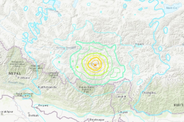
According to the United States Geological Survey, the epicenter of this 7.1 magnitude earthquake was located in the Tibetan region with a depth of about 10 kilometers. China recorded the earthquake as a magnitude 6.8.
The Indian National Seismological Center (NSC) also recorded the earthquake as a 7.1 magnitude tremor. The epicenter was at the collision point of the Indian Plate and the Eurasian Plate, causing the Himalayan mountain range to rise, with enough intensity to potentially alter the heights of some of the world’s tallest peaks. Several aftershocks occurred following the main earthquake, with magnitudes reaching up to 4.9.
Xinhua News Agency reported that at least 32 people have died and 38 others were injured in Tibet. Due to the Chinese government’s consistent concealment of data, the actual situation may be worse.
A video circulating on social media showed the aftermath of the earthquake in nearby town of Lazi, displaying destroyed storefronts and scattered debris on the roads.
Reuters confirmed the earthquake location by matching nearby buildings, windows, road layouts, and signs with satellite and street view images.
According to the China Meteorological Administration, the temperature in Dingri is around -8 degrees Celsius (46 degrees Fahrenheit) and is expected to drop to -18 degrees Celsius on Tuesday night.
Approximately 400 kilometers (250 miles) from the epicenter, the Nepalese capital Kathmandu also felt the tremors, prompting local residents to evacuate their homes.
Reacting to the earthquake, Anoj Raj Ghimire, the Chief District Officer of Solukhumbu in Nepal, stated, “We felt a very strong earthquake. So far, we have not received any reports of casualties or property damage.” The area is located closer to the base of the world’s tallest peak, Mount Everest.
Jagat Prasad Bhusal, a government official in Namche region of Nepal, mentioned, “The vibration was quite strong here; everyone woke up.” This region is closer to Mount Everest compared to other areas.
Reports from the Indian financial newspaper Livemint indicated that the earthquake affected northern India and Nepal, prompting social media users to describe it as “extremely terrifying” and as a “natural alarm clock set by nature in the morning.”
An individual from Nepal shared on social media, “Honestly, this is a very scary earthquake, I think it lasted for over a minute; my body is still trembling, and the painful memories of the 2015 earthquake keep coming back to me. I hope and pray for everyone’s safety.” Referring to the 2015 Nepal earthquake of 7.8 magnitude, which resulted in nearly 9,000 deaths and over 22,000 injuries.
“7.1 magnitude is insane. This is the first time I’ve felt an earthquake since 2015. Insane!” added another user on social media.
“This earthquake lasted a long time, it’s frightening,” said a user while sharing a video clip.
The earthquake also affected Thimphu, the capital of Bhutan, and the Indian state of Bihar, bordering Nepal.
An Indian citizen posted on social media, “Oh my, I woke up so early because of a big earthquake.”
Indian officials stated that as of now, no reports of property damage or destruction have been received.
According to the United States Geological Survey, in the past century, the region where the earthquake occurred on Tuesday has experienced 10 earthquakes of magnitude 6 or above.
In 2008, a major earthquake in Sichuan Province in China led to nearly 70,000 deaths, while the 7.8 magnitude earthquake near Kathmandu in 2015 was the deadliest earthquake in Nepal’s history.