
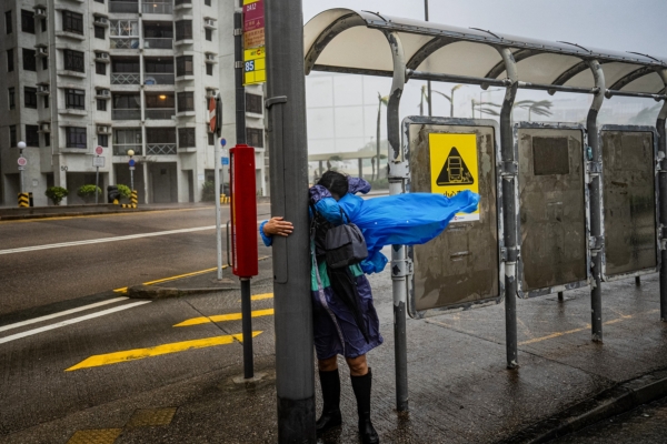
Due to the impact of the super typhoon “Ragasa” in Hong Kong, the Hong Kong Observatory issued the No. 10 hurricane signal at 2:40 am on the 24th, commonly known as the “No. 10 typhoon signal”. This is the second time this year that Hong Kong has raised the No. 10 typhoon signal and the second time within one year since 1964 that the highest-level tropical cyclone warning signal has been issued. Subsequently, at 2:45 am, the Hong Kong Observatory also issued a yellow rainstorm warning.
The No. 10 typhoon signal indicates that the wind force has reached or is expected to reach hurricane level, with sustained winds of over 118 kilometers per hour, gusts exceeding 220 kilometers per hour.
The Hong Kong Observatory predicts that the typhoon will come closest to Hong Kong in the next few hours, passing about 100 kilometers to the south, posing a serious threat to Hong Kong. The No. 10 hurricane signal will be maintained for a period of time.
According to reports in the Hong Kong media earlier, the severe weather has already led to 5 injuries. As of 4:00 am, authorities have received reports of 30 fallen trees and 1 landslide. A total of 49 temporary shelters across Hong Kong have accommodated more than 700 people. The Education Bureau had previously announced that all schools would be closed on the 24th.
The Macao Meteorological and Geophysical Bureau also issued the highest-level typhoon warning signal, the No. 10 typhoon signal, at 5:30 am on the 24th, expected to be maintained for a period of time. As of 3:00 am, the Macao Civil Protection Operations Center had received 9 accident reports, with one person injured, and a total of over 600 people accommodated in 17 shelters.
Mainland China is also on high alert, with more than a dozen cities in Guangdong, Hainan, and other areas already halting operations, implementing the “Five Stops” (school closure, work suspension, production halt, transportation suspension, business closure). The China Meteorological Administration predicts that “Ragasa” will make landfall along the coast from Zhuhai to Zhanjiang in Guangdong, bringing typhoon-level or severe typhoon-level winds from noon to evening on the 24th.
Prior to this, “Ragasa” struck northern parts of the Philippines, resulting in at least 3 deaths and 5 people missing.