Next Week, Historic Heatwave Expected in Central and Eastern United States
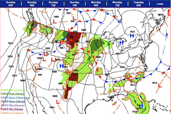
In the midst of a historic heatwave expected to hit the midwestern and eastern regions of the United States next week, Montana, a state in the U.S., is expected to experience June snowfall. On Saturday, June 15th, a cold upper-level low-pressure system moved into the Pacific Northwest region, and is forecasted to enter the mountainous regions of the western United States in the beginning of next week.
The National Weather Service in the United States stated on Saturday, June 15th, that a series of unusually strong upper-level low-pressure systems will pass through the northern Great Basin from the eastern part of the Pacific Northwest in mid-June, moving into the northern Rocky Mountains. The lower temperatures will further spread to the south into the Great Basin and are expected to enter the northern plains on Monday, June 17th.
The National Weather Service said, “Winter storm warnings are in effect, with the possibility of several inches of snow in mountainous areas. While lower elevations are expected to mainly receive cold rain, some higher elevation valleys may see a mix of snow.”
The first areas to be impacted will be the western region of Seattle and the state of Washington, where a rare round of thunderstorms is expected. Temperatures in Seattle are forecasted to struggle to break 50 degrees Fahrenheit, and snow levels in the Cascades are expected to drop—low enough for some hikers to witness wet snow, while snow accumulation continues on higher peaks.
As the cold air expands eastward, frost advisories are in place on Sunday morning covering large areas in the eastern part of Washington and northern Idaho, with temperatures expected to drop to around 30 degrees, potentially causing damage to sensitive crops and plants. Following that, the upper-level low-pressure system will move into western Montana, with significant snow expected in the northern Rocky Mountains.
Fox News reported that this week, a winter storm warning was issued for large parts of Montana in the United States, with snowfall forecasts ranging from 1 to 3 inches at Lost Trail Pass, 3 to 6 inches in the Sapphire and Bitterroot ranges, and mountain ranges above 6,000 feet potentially receiving 6 to 14 inches of snow.
With a few days remaining until the summer solstice, the cold snap won’t linger as long-term forecasts indicate that by the end of next week, temperatures in these regions will quickly rebound to seasonal averages, with the likelihood of hot weather returning post next weekend.

