
The Taiwan Central Weather Bureau forecasts that Typhoon “Pulasan” will be closest to Taiwan on the 19th (Thursday). The bureau stated today (Monday the 16th) that a tropical depression formed at 8 a.m., with expectations of strengthening into Typhoon “Sulik.” On the 17th (Tuesday), which is also Mid-Autumn Festival, areas like Greater Taipei (Taipei City, New Taipei City, Keelung City), and the eastern region will have a lower chance of moon-viewing.
According to the Taiwan Central Weather Bureau, the center of the tropical storm “Pulasan” was located at 15.4 degrees north latitude and 143.9 degrees east longitude at 8 a.m. on the 16th, moving northwest at a speed of 21 kilometers per hour. The central pressure is 998 hPa, with maximum sustained winds near the center at 18 meters per second, and maximum gusts at 25 meters per second. The average radius of strong winds is 80 kilometers (60 kilometers on the northwest side, 100 kilometers on the northeast side, 60 kilometers on the southwest side, and 100 kilometers on the southeast side).
At 9:50 p.m. on the 15th, Typhoon No. 14, named “Pulasan” internationally, was formed. The Taiwan Central Weather Bureau predicts that it will move towards the northeastern sea area of the Ryukyu Islands, so please stay updated with the latest typhoon information released by the bureau.
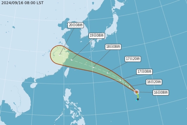
Forecaster Chu Mei-lin of the Taiwan Central Weather Bureau mentioned in a press conference that Tropical Depression No. 17 was formed in the eastern Philippine Sea at 8 a.m. today, with a trend of potentially developing into a tropical storm, likely to become Typhoon No. 15 of this year, named “Sulik.” It is expected to move towards the South China Sea, gradually intensifying but having no direct impact on Taiwan. On the Mid-Autumn Festival on the 17th, areas south of Hsinchu, Penghu, and Kinmen have a higher chance of clear moon-viewing, while areas north of Taoyuan and Matsu will be cloudy with possible rainfall, offering relatively lower moon-viewing chances in the eastern region.
The Taiwan Central Weather Bureau estimates that Typhoon “Pulasan” will be closest to Taiwan on the 19th, with northern and eastern regions likely to experience local brief showers and coastal areas advised to watch for possible high waves. The later trajectory remains uncertain. The bureau also forecasts that on the Mid-Autumn Festival on the 17th, the eastern region, Keelung’s northern coast, and Hengchun Peninsula might experience rainy weather; Taipei City and New Taipei City will have mostly cloudy skies with occasional rain showers, presenting a gamble for moon-viewing.
Associate Professor Wu Derong of the Department of Atmospheric Sciences at National Central University commented on the situation, stating in “SET Weather Forecast: Old Predictions Revealed” that according to the Central Weather Bureau’s “Path Potential Prediction Chart” at 2 a.m. today, Typhoon No. 13, “Babika,” is nearing landfall and weakening gradually as it moves towards the northwest in the Yangtze River Delta. Typhoon No. 14, “Pulasan,” near Guam, has a path slightly south of Typhoon “Babika,” within an uncertain range.
Wu Derong further mentioned that the latest (8 p.m. on the 15th) model simulation from the United States’ GEFS indicates another disturbance brewing near Luzon Island. Due to the highly variable atmospheric conditions, the model simulations show widely dispersed paths, indicating uncertainties in future movements. As it is closer to Taiwan, further observation is needed.
Regarding the upcoming Mid-Autumn Festival on the 17th, Wu Derong highlighted that the eastern side of Taiwan will have increased moisture content, leading to greater cloud cover in Greater Taipei and the eastern region, with a chance of scattered brief showers. The western region will experience cloudy intervals and sporadic brief showers in mountainous areas during the afternoon. On the 18th, there is a possibility of local brief showers in the north and east, and the western region near mountainous areas may experience isolated showers or thunderstorms in the afternoon. The weather from the 19th to the 22nd will depend on the movements of Typhoon “Pulasan” and another tropical system, with frequent model adjustments underway, requiring further observation.