
On January 12th, at the Pasadena Civic Center, displaced residents from Altadena and nearby cities gathered in front of a large map of the fire-affected area. Their faces were dazed, bearing the trauma in their hearts, carrying blankets and backpacks, staring at the paper map depicting the fire perimeter that had destroyed their lives.
Sima Alam, a 49-year-old resident of Altadena, knew shortly after evacuating on January 7th that her home was no longer standing. She expressed, “As you can see, this is everything to me. I just want to figure out where to go next.”
“My emotions… I am very overwhelmed,” she said. “I can’t even drive through the neighborhood where I grew up. I can’t bear to look at these burned buildings.”
While some residents were fortunate that the fire did not touch their neighborhoods, many are still uncertain about the status of their properties. Authorities continue to restrict residents from returning to the evacuated areas, leaving them anxious for information to track the situation as losses are assessed.
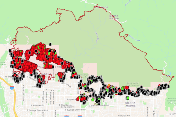
This week, Los Angeles County unveiled an interactive map to evaluate the damage caused by the Pacific Palisades and Altadena fires, as well as other areas affected by the Eaton fire on the west side of Los Angeles.
Each building on the map is marked with color-coded symbols. Red signifies destruction (damaged over 50%), black indicates no damage, while other colors represent varying degrees of damage. Residents can input their address, click on their homes, commercial buildings, or other structures to view the assessment and additional photos.
The map is a work in progress and will be continuously updated as forestry and fire departments survey the areas. Kathryn Barger, Chair of the Los Angeles County Board of Supervisors, emphasized the importance of the map as a reliable source of information for residents to understand their property losses and initiate recovery processes.
Barger’s district includes Altadena, an unincorporated area near the San Gabriel Mountains. The Eaton fire has scorched over 14,000 acres of land since January 7th. In the western end of Los Angeles County, the Pacific Palisades fire has consumed over 23,700 acres, with approximately 19% contained.
Both fires are believed to have damaged over 12,300 structures. Firefighters made progress over the weekend in battling the Eaton fire, with containment reaching 45% as resources and personnel increased.
As of Tuesday evening, the Los Angeles County coroner reported 9 fatalities in the Pacific Palisades fire and 16 in the Eaton fire. Over 500 officers were dispatched to patrol the Altadena area last week, supported by the California Highway Patrol and National Guard, to ensure residents’ safety and deter looters during the enforced curfew from 6 p.m. to 6 a.m.
Evacuees shared that during the early stages of the fires, many residents returned home when the winds calmed, easily circumventing the roadblocks on major thoroughfares.
Jack Green, an Altadena resident of 37 years, evacuated his home. He mentioned, “They weren’t patrolling on the streets, just certain spots, so it was very easy to come in and out, and on Wednesday night, the cars there obviously weren’t from this community.”
Green shared that his friend’s home was looted after being burned. Authorities continue urging residents not to enter evacuation zones or other restricted areas for any reason.
Officials cautioned in the online FAQs accompanying the damage condition map, “Although the fire threat in certain areas may have diminished, there are still many hazards, including downed power lines, hazardous materials, fallen trees and other obstacles blocking roads, contaminated water, poor air quality, and other dangers.”