
In just three days, the “Bridge Fire” that broke out in the San Gabriel Valley in the Los Angeles Chinese community has now spread from Los Angeles County to San Bernardino County. Many Chinese residents can see the raging fire from their homes, with thousands of people already evacuated.
The “Bridge Fire” erupted around 2 p.m. on September 8th and by the afternoon of the 10th, the fire suddenly intensified, burning nearly 50,000 acres of land and continuing to blaze in Los Angeles and San Bernardino counties. This wildfire is considered the largest active wildfire in California at the moment, with a containment rate of 0%.
On the evening of the 10th, residents in high-density Chinese cities such as Arcadia, El Monte, San Gabriel, and Azusa could feel the tense atmosphere as the fire approached.
Ms. Liu stated that while driving west on Highway 10, she could clearly see thick smoke rising from the mountains to the north, with clusters of flames burning. “By around 9 p.m., there was heavy traffic on the highway, and the air was filled with a choking smoke smell, as if the fire was right next to residential areas.”
Residents living in Azusa and Upland said they received evacuation alerts from the Los Angeles County Fire Department four times continuously from 8 p.m. to 1 a.m., urging residents in the vicinity of the active fire zone to have evacuation plans in place.
The Los Angeles County government reminds the public that once their area receives an evacuation order, individuals must leave immediately in accordance with the law, and no one is allowed to re-enter until the order is lifted.
Local authorities have issued evacuation orders for areas near Angeles Crest Highway north of the Largo Vista area, the San Gabriel Reservoir, the Morris Reservoir east of the reservoir, the East Fork communities of Camp Williams Resort, Mt. Baldy Resort from the dam to Los Angeles County’s highest peak, and the Wrightwood community.
As of the evening of the 10th, roads were heavily congested, with residents of the entire Wrightwood community lining up to evacuate. As of the deadline, evacuation orders and alerts remained in effect.
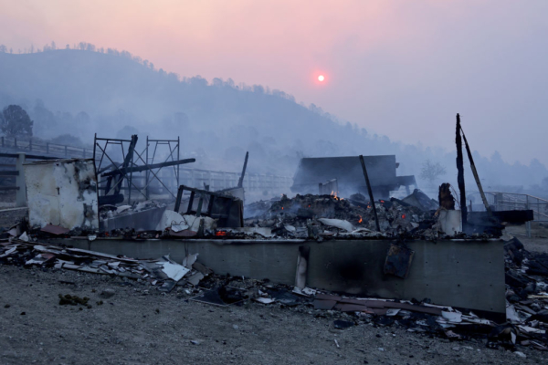
The Los Angeles County Fire Department reported that more than 30 homes in the Mt. Baldy and Wrightwood areas have been destroyed by the “Bridge Fire,” with the fire still threatening nearly a hundred surrounding buildings and causing damage to power infrastructure.
Sections of San Gabriel Canyon, San Gabriel River East Fork, Highway 39, Glendora Ridge Road, and Glendora Mountain Road have all been closed.
In order to speed up the containment of the wildfire, Los Angeles County has declared a local state of emergency. The public can obtain the latest fire information through the official website “lacounty.gov/emergency” or by calling 2-1-1.
In addition to Los Angeles County, the San Bernardino County government has also issued emergency evacuation orders for certain local areas, including the BLD01, WWD01, WWD02, WWD03, PIN01, and PIN02 areas. Furthermore, the immediate evacuation range includes the region south of Highway 138 to Lone Pine Canyon and east of Highway 2 to Lone Pine Canyon Road.
The temporary shelters open in Los Angeles and San Bernardino County are as follows:
1. Antelope Valley Fairgrounds (2551 W Avenue H, Lancaster, CA 93536);
2. Pomona Fairplex (601 W McKinley Ave, Pomona, CA 91768), enter through gate 3 and park cars next to the hotel, then follow the red cross signs to Building 5 of the fairgrounds;
3. Jesse Turner Health and Fitness Community Center (15556 Summit Avenue, Fontana);
4. San Bernardino County Fairgrounds Building 6 (14800 7th St, Victorville, CA 92395).
It is worth noting that the shelter at the Hacienda Heights Community Center is now closed.
As of 5 p.m. on September 11th, two other wildfires were rapidly spreading in Southern California: the “Line Fire” in San Bernardino County and the “Airport Fire” in Orange County. The “Line Fire” has burned 34,729 acres of land with a containment rate of only 14%; the “Airport Fire” has burned 22,910 acres of land with a containment rate of 0%.