
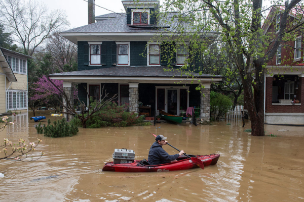
Central New Mexico is facing another flood crisis as heavy rains triggered flash flooding in the south mountain town of Ruidoso due to monsoon storms. Within hours, the Rio Ruidoso river surged to about 20 feet, well above the 15-foot flood warning line. A whole building was swept away by the flood, leaving several residents trapped in the area.
The National Weather Service office in Albuquerque issued a warning on Tuesday, stating, “The Ruidoso area is in a dangerous condition, and the flash flood emergency continues to be in effect! Please evacuate to higher ground immediately! Do not attempt to drive through flooded waters, as the swift current may sweep away your vehicle!”
Within an hour of the first flash flood warning issued by the weather bureau, the Rio Ruidoso river had reached the 15-foot flood alert level. As of Tuesday night, three people were reported missing, with no fatalities confirmed as authorities wait for the floodwaters to recede to assess the severity of the situation.
Danielle Silva from the New Mexico Department of Homeland Security and Emergency Management stated that emergency rescue teams conducted at least 85 water rescues in the Ruidoso area, successfully rescuing multiple individuals trapped in their homes and vehicles.
Mayor Lynn D. Crawford of Ruidoso expressed in a broadcast on Tuesday night that the flood disaster was more severe than anticipated. Some individuals have been hospitalized due to flood-related incidents, with the exact number yet to be confirmed. He urged residents to call the emergency hotline if they have lost contact with family or neighbors.
Social media platforms have been flooded with videos depicting the rushing waters, with some capturing the harrowing scenes of entire houses being swept away by the flood.
In the mountainous region, after 4 pm local time, Lincoln County in central-south New Mexico issued flash flood warnings due to ongoing thunderstorms affecting the Blue 2 Fire burn scar area. The weather service warned that continued heavy rainfall in the fire-affected area may cause rapid rises in the Rio Bonito and Eagle Creek upstream levels.
Areas at risk include structures along Forest Service Road 107, the Bonito Lake Area, the Rio Bonito River bridges on Highways 37 and 48, and downstream areas along Highway 48 along the Rio Bonito River.
The warning stated that the floods could carry rocks, mud, vegetation, and other debris, increasing the risk of disasters. By 4:06 pm, the region had received 0.25 to 0.5 inches of rain, with potential for up to 0.75 inches of rainfall in the warned areas.
Greg Waller, a hydrologist from the West Gulf River Forecast Center in Fort Worth, Texas, highlighted that the intensity of flooding depends on the speed of rainfall at a specific location, not just the total rainfall accumulation. For instance, “Two inches of rain in 24 hours versus two inches in half an hour could result in very different surface runoff patterns.”
In the South Fork Fire burn scar region surrounding areas like Ruidoso, Ruidoso Downs, and Hollywood, the flash flood warning remains in effect until at least 7:15 pm. The local emergency management department reported that the Ruidoso area is facing ongoing flash floods and mudslides.
Since the last warning, an additional 1.3 to 3.5 inches of rainfall has been recorded in the region.
The atmospheric bureau pointed out that the soil in the fire-affected area has been saturated due to significant rainfall and flooding on Monday, making it susceptible to rapid surface runoff in the coming days, potentially leading to floods. They cautioned of a slight risk of severe thunderstorms with damaging winds, large hail, and frequent lightning in the afternoon to late evening.
“However, some storms may bring localized heavy rainfall to southern regions.”