
Taiwanese meteorological experts stated today (October 23rd) that Typhoon Tammy will have the most significant impact on Taiwan on the 24th and 25th, as strong windward areas should be cautious of heavy rainfall leading to disasters.
The Central Weather Bureau of Taiwan mentioned that today marks the “Frost Descent,” one of the 24 solar terms, where many people should feel the weather getting colder when they wake up. This is mainly due to the influence of the northeast monsoon. Although the southern Typhoon Tammy did not directly hit Taiwan, it is necessary to remind everyone that from today to the 25th, the northeastern monsoon and the peripheral circulation of the typhoon will bring strong winds and heavy rain to different regions.
Associate Professor Wu Derong of the Department of Atmospheric Sciences at National Central University in Taiwan stated on “Sanli Weather Forecast” that according to the latest European model ensemble simulation map at 8 p.m. on the 22nd, the northeast monsoon strengthened today, with localized rain in the northern and northeastern parts, and occasional short rain in the east; there will be heavy rain on the north coast and northeastern regions. Northern Taiwan will turn cool and moist again. The temperatures in different regions are expected to be 20-26 degrees in the north, 21-31 degrees in the central region, 21-33 degrees in the south, and 21-31 degrees in the east.
Wu Derong mentioned that on the 24th and 25th, the peripheral circulation of Typhoon Tammy may experience uplift due to the terrain, increasing the probability of heavy rainfall in the windward northern and eastern regions. Strong winds are expected over the nearby Taiwan waters and certain coastal areas, so attention should be paid to the special alerts issued by the Weather Bureau. In the leeward plains, shielded by the Central Mountain Range, the impact will be minor, but mountainous areas will still experience heavy rain. The northern and eastern regions will significantly cool down, while temperatures in other areas will slightly drop.
Wu Derong added that on the 26th, Typhoon Tammy will gradually move away, causing significant rainfall in the eastern region and afternoon localized showers or thunderstorms in the western region, requiring continued vigilance for heavy rain. Unstable atmospheric conditions on the 27th may lead to convective development in the afternoon in mountainous areas and the central and southern regions. The temperatures will significantly rise over the weekend, with daytime heat and slight chill in the mornings and evenings. Another northeastern monsoon will impact Taiwan on the 28th and 29th, leading to cooler temperatures in northern Taiwan and localized brief rain in the northern and eastern regions.
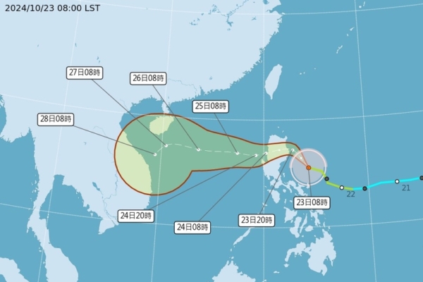
He stated that the European model ensemble simulation map shows that the average path of the ensemble is close to the “potential forecast map” path, with individual simulated paths dispersed on either side but relatively converging. Due to the moderate structure of Typhoon Tammy, it has a large circulation, leading to conditions conducive for heavy rainfall on the windward side due to the uplift of the terrain. As the cold air from the north has not descended in time, there is no convergence of cold and warm air to form a stationary front, covering the northern and northeastern areas; in other words, the “autumn typhoon companion effect” of Typhoon Tammy is not significant.