
The Taiwan Central Weather Bureau announced the formation of a light typhoon, Gingko, at 2 a.m. today. Meteorological experts pointed out that Typhoon Gingko is expected to move northwest for the next 3 days and approach the southeastern sea area of Taiwan in 3 to 5 days, moving slowly westward with an expanding range of uncertainty.
The Taiwan Central Weather Bureau revealed that at 2 a.m. today, the center of the light typhoon Gingko was located at 12.2 degrees north latitude and 133.4 degrees east longitude, moving west-northwest at a speed of 32 kilometers per hour. The central pressure was 988 hPa, with a maximum wind speed near the center of 23 meters per second and maximum gusts of 30 meters per second, with a radius of strong winds averaging 100 kilometers (100 kilometers on the northwest side, 100 kilometers on the northeast side, 90 kilometers on the southwest side, and 90 kilometers on the southeast side).
The Taiwan Central Weather Bureau issued a land strong wind special report on Facebook today, indicating that the northeast winds are strengthening. From today, the coastal and open areas from Taoyuan to Tainan, as well as the Hengchun Peninsula, Green Island, Orchid Island, Penghu, Kinmen, and Matsu, are expected to experience strong gusts of wind at force 8 to 9. By the morning of the 5th, areas from Taoyuan to Yunlin along the coast, as well as the Hengchun Peninsula, Green Island, Orchid Island, Penghu, Kinmen, and Matsu, may face force 9 to 10 strong gusts of wind. Locations near Keelung’s northern coast, Chiayi, Tainan, and the east coast may also experience stronger gusts of wind, with rough seas in the adjacent waters.
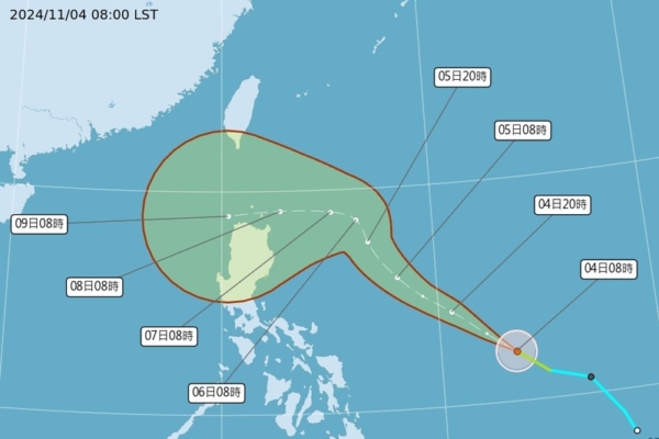
Associate Professor Wu Derong of the Department of Atmospheric Sciences at National Central University in Taiwan stated in an interview with “Sanlih Weather Forecast: Reveal the Secrets” today that the central weather bureau’s “potential path prediction map” at 2 a.m. on the 4th shows that Typhoon Gingko will move northwest in the next 3 days and approach the southeastern sea area of Taiwan in 3 to 5 days, slowing its speed and slowly shifting westward, with an expanding range of uncertainty.
Wu Derong mentioned that the latest European (ECMWF) ensemble model simulation on the night of the 3rd indicates that after 3 days, the individual simulated paths of Typhoon Gingko are roughly divided into two. The main track turns westward, passing near Luzon into the South China Sea, while a smaller track loops northeast. Therefore, the ensemble average path is to pass through the northern part of Luzon into the South China Sea, but there is significant uncertainty. Currently, there is no direct probability of landfall in Taiwan, and the indirect “companion effect” is not strong. The adjustments in the future will be crucial to monitor.
Wu Derong also added, “During the daytime today, there is a chance of some spotty, scattered rainfall on the windward side of the north coast, eastern regions, and southern mountainous areas, with mostly sunny to partly cloudy weather elsewhere. Rain probabilities increase slightly in the Taipei area starting in the evening. It will be comfortable in the north and slightly warm in the south during the day, with cool mornings and evenings. Temperatures will range from 18 to 28 degrees in the north, 21 to 33 degrees in the central region, 22 to 33 degrees in the south, and 19 to 31 degrees in the east.”
Regarding the weather outlook, Wu Derong mentioned that the latest European model simulation indicates that from the 5th to the 7th, the influence of the northeast monsoon will bring brief showers to areas north of Taoyuan and the eastern region on the 5th. By the 6th and 7th, conditions will turn slightly dry, with mostly cloudy skies in the north coast, northeast, and eastern regions, alongside a chance of scattered, spotty rainfall. Leeward areas will experience sunny and stable weather. Starting from the 5th, temperatures will gradually decrease day by day. Northern Taiwan will feel cooler, while the central and southern regions will be slightly warm during the day and cool in the mornings and evenings. Although the cold air is not strong, radiative cooling will lead to minimum temperatures of around 16 degrees Celsius on the plains of the island on the 6th and 7th.
He also mentioned that from the 8th to the 10th, moisture on the east side of Taiwan will gradually increase due to Typhoon Gingko. Areas in the north and east will have localized showers, and the intensity of the rainfall will depend on the strength of the “companion effect,” requiring continuous monitoring. Areas south of Hsinchu will continue to experience sunny and stable weather. The cold air will slightly weaken, and temperatures will slightly rise.