
Taiwanese meteorological experts have stated that despite the formation of four typhoons over the past week, only Typhoon Maria and Typhoon Ampil have had impacts on Japan, while Typhoon Shanshen and Wukong have not affected any land.
This week, the western half of Taiwan will experience brief showers and heavy thunderstorms in the afternoons. Starting from the 19th, southwestern seasonal winds will affect Taiwan, bringing the need to be vigilant against potentially devastating rainfall.
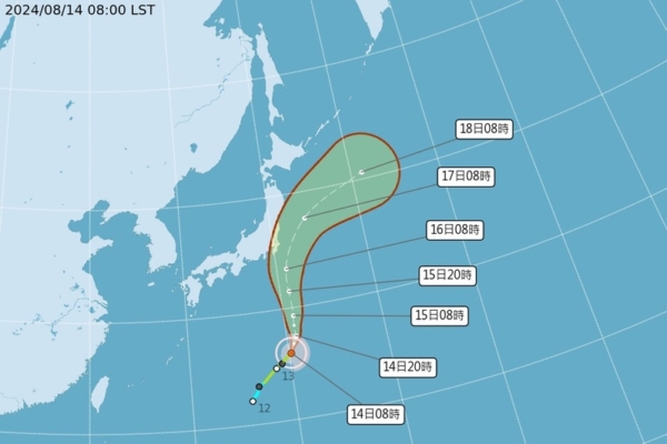
The Central Weather Bureau of Taiwan disclosed that Tropical Storm Ampil, internationally named as AMPIL and given the number 7, had its center positioned at 26.0 degrees north latitude and 140.2 degrees east longitude at 8 a.m. today. It is moving at a speed of 16 kilometers per hour towards the north-northeast. The central pressure is 975 hPa, with a maximum wind speed near the center of 30 meters per second and maximum gusts of 38 meters per second. The radius of strong winds at Beaufort scale level 7 extends up to 150 kilometers from the center, while at level 10 it reaches 30 kilometers.
Wu Derong, associate professor in the Department of Atmospheric Sciences at Central University of Taiwan, pointed out in his column that the monsoon circulation has led to the formation of multiple typhoons. He cautioned about the possibility of heavy thunderstorms in the upcoming week and estimated that Tropical Storm Ampil is likely to intensify into a moderate typhoon. Guided by a large low pressure system, it is projected to pass over the southeastern side of Honshu, Japan on the 16th before rapidly moving away.
Wu also mentioned that Tropical Storm Wukong, currently located over the eastern sea of Japan, is moving north-northwest and is far from Japan. Despite the formation of four typhoons within the next week, only Typhoon Maria has made landfall in northern Honshu, Japan, and Typhoon Ampil is predicted to pass close to the southeast side of Honshu. Typhoons Shanshen and Wukong have had no impact on any land areas.
According to the latest European model simulation as of 8 p.m. on the 13th, the monsoon circulation pattern is expected to persist until the 18th. Taiwan will be at its edge, with prevailing southwestern winds carrying moisture and creating unstable atmospheric conditions. Temperatures across various regions from the 14th to the 18th are expected to be around 35-36 degrees Celsius, staying relatively hot. In the mornings, the convergence of southwestern winds and land breezes may bring localized brief showers to the western region, while thunderstorms may develop and expand in the afternoons, leading to heavy rainfall. Vigilance against severe weather events such as thunderstorms, strong winds, and heavy rain is advised.
Wu further added that the latest model simulations suggest that from the 19th onwards, the Pacific high pressure system will gradually strengthen and extend westward, with the southwestern seasonal winds passing through Taiwan on the 19th and 20th. Due to topographical features, the risk of destructive rainfall must be taken seriously, as the threat is significant and should be closely monitored.