
Taiwanese meteorological experts have indicated that there is a tropical system expected to pass through the eastern waters of Taiwan on the 24th and 25th, with an intensity of around a tropical depression or a weaker typhoon, prompting precautions for heavy rainfall in northern Taiwan.
Associate Professor Wu Derong from the Department of Atmospheric Sciences at National Central University in Taiwan stated today (22nd) in the “Air Classroom” column of the Meteorological Application and Outreach Foundation that according to the latest European model (ECMWF) simulations as of 8:00 pm on the 21st, for the next two days, the atmosphere remains unstable within the monsoon circulation. There will be localized showers or thunderstorms in the eastern half of Taiwan and in the mountainous areas of the western half in the afternoon, with a chance of extending to some flatlands. Due to continuous rainfall in the east, the soil may become soft, so activities in mountainous areas should be avoided.
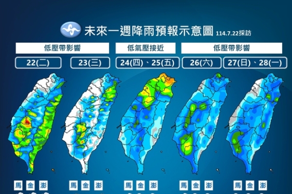
Wu Derong mentioned that the latest model simulations show that on the 24th and 25th, the influence of the tropical system and monsoon circulation will lead to significant rainfall in northern Taiwan, occasionally accompanied by strong gusts. In the central and southern regions, there is a probability of localized showers or thunderstorms in the afternoon. From the 26th to the 28th, under the influence of the monsoon circulation, the atmosphere will still be unstable with a chance of localized showers or thunderstorms throughout the region. The convective activity will be strong in the afternoon, making the weather hot and humid when it is not raining.
According to Wu Derong, the latest “Path Potential Prediction Map” released by the Meteorological Agency at 2:00 am on the 22nd shows that Typhoon Vipa is currently in Tokyo Bay and is expected to make landfall at noon today, affecting the northern part of Vietnam. The latest European model ensemble path simulation indicates that the tropical system will pass through the eastern waters of Taiwan and enter the northern waters but due to strong vertical wind shear and loose structure, it is only likely to develop into a tropical depression or a relatively weak “light typhoon”.
He added that the latest ensemble path simulation map by the United States model (GEFS) as of 8:00 pm on the 21st shows another tropical system in the waters north of Guam, with a stronger intensity. The simulated paths are mainly towards the north, far from Taiwan without posing any threat, so there is no need to worry about its impact on Taiwan.