
Taiwanese meteorologist Wu Derong said that Typhoon Kong-rei cannot be ruled out from making a direct landfall and poses a considerable threat to Taiwan. The impacts of Typhoon Kong-rei from October 31 to November 1 could pose a serious threat to Taiwan; therefore, early typhoon preparedness measures should be taken.
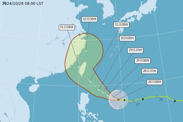
According to the Taiwan Central Weather Bureau, the center of Tropical Storm Kong-rei was located at 16.8 degrees north latitude and 129.0 degrees east longitude as of 8 a.m. on the 28th of October, moving westward at a speed of 13 kilometers per hour. The central pressure was 980 hPa with maximum sustained winds near the center of 28 meters per second and maximum instantaneous wind gusts of 35 meters per second. The radius of gale-force winds extends up to 220 kilometers (240 kilometers on the northwest side, 200 kilometers on the northeast side, 240 kilometers on the southwest side, and 200 kilometers on the southeast side).
Associate Professor Wu Derong from the Department of Atmospheric Sciences at National Central University in Taiwan mentioned on a program that the latest model simulations show that on October 29 and 30, the northeastern monsoon will bring brief showers to the windward areas of northern and eastern Taiwan. On October 31, as the outer moist air of Typhoon Kong-rei moves in, rainfall duration will increase and amounts will rise, while the leeward regions in central and southern Taiwan will experience partly cloudy skies. The temperatures will gradually drop day by day, making northern Taiwan cool and damp.
Wu emphasized that the impact of Typhoon Kong-rei on Taiwan on October 31 and November 1 poses a serious threat, requiring early typhoon preparedness measures to be put in place. The intensity of winds and rain in different areas will depend on the trajectory adjustments. By November 2 and 3, Typhoon Kong-rei is expected to move away from Taiwan, leading to improved weather conditions.
Providing further insight, Wu highlighted that the latest official forecast paths (as of 2 a.m. on the 28th) indicate that Typhoon Kong-rei is now predicted to make landfall in Taiwan. Both the Taiwan Central Weather Bureau and the Japan Meteorological Agency anticipate that, as it reaches its peak intensity before any disruption by land, the average wind speed near the center could reach 48 meters per second, making it a severe typhoon at its limit. The threat posed should not be underestimated. While the possibility of intensification into a powerful typhoon cannot be ruled out, there has been confusion in some media portraying the “Japan Meteorological Agency” as forecasting it as a strong typhoon, suggesting a misinterpretation of data.
Considering the latest ensemble model simulations from Europe (as of 8 p.m. on the 27th), it indicates that the ensemble mean path of Typhoon Kong-rei could potentially lead to a landfall in Taiwan with a significant number of paths favoring bordering seas without landfall. This underscores the considerable “uncertainties” in the official forecast paths of various countries, warranting a continuous observation and adjustment of data. Meanwhile, Typhoon Tiane is soon to exit Vietnam and return to the South China Sea, where it is expected to weaken into a tropical low-pressure system.