
Taiwanese meteorologist Wu Derong said today (14th) that the latest European and American models show that a tropical system developing within the monsoon low-pressure system is expected to pass through the Bashi Channel, not far from Taiwan, posing a significant threat.
In his column on the Meteorological Application and Promotion Foundation’s “Sky Leakage Classroom”, Wu, an associate professor at the Department of Atmospheric Sciences at National Central University in Taiwan, mentioned that the latest European model (ECMWF) simulated on the evening of the 13th showed that it would be mostly cloudy with occasional sunshine today, remaining hot and humid. There is a slight increase in moisture, with the probability of localized thunderstorms in mountainous areas in the afternoon, occasionally extending to some nearby plains. Temperatures are expected to range from 26 to 35 degrees Celsius in the north, 24 to 36 degrees in the central region, 24 to 35 degrees in the south, and 23 to 37 degrees in the east.
Wu pointed out that the latest model simulations indicate that it will continue to be mostly sunny with some clouds in the afternoon from the 15th to the 17th, remaining hot. There is a probability of brief precipitation in the early morning and late morning in the central and southern regions due to the convergence of the land breeze and southwest wind, with localized thunderstorms in mountainous areas in the afternoon, occasionally affecting some nearby plains. On the 18th, there will be brief thunderstorms in the western part in the afternoon, while the eastern part will see an increase in moisture in the evening, leading to the possibility of localized showers. The weather on the 19th and 20th will be influenced by the movement of a “tropical system” and will need further observation.
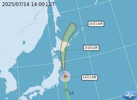
Regarding the track of this year’s Typhoon Lily, Wu stated that as of 2 a.m. on the 14th, the Meteorological Administration’s “path potential prediction chart indicates that the tropical storm Lily will move northward on the 14th and 15th, passing over the eastern coast and waters near Honshu and Hokkaido in Japan, then heading northeast away from Taiwan, posing no threat.
Wu also mentioned that the latest model simulations from various countries on the evening of the 13th indicate that starting from the 18th, the “monsoon low-pressure system” will gradually shift northward. Both the European (ECMWF) and American (GFS) models show that for the 5th to 8th day, a “tropical system” developing within the “monsoon low-pressure system” is expected to pass through the Bashi Channel, not far from Taiwan, indicating a significant threat that should not be underestimated.
Furthermore, he noted that on the 9th and 10th days of the simulation, another “tropical system” is predicted to be active in the waters off the eastern coast of Taiwan. Models from various countries are still being adjusted, and close observation is necessary.