
A super typhoon named “Hua Jia Sha” is projected to directly hit Guangdong Province in China. The typhoon’s center is expected to have wind speeds exceeding 17 levels, with a massive size surpassing the entire area of Guangdong Province, earning it the title of the strongest “Wind King.” “Hua Jia Sha” is predicted to severely impact both the sea and land areas of Guangdong Province from the 23rd to the 25th of September. Various regions in Guangdong have issued early warnings, and measures such as class suspensions, work stoppages, production halts, transportation shutdowns, and business closures may be implemented during this period.
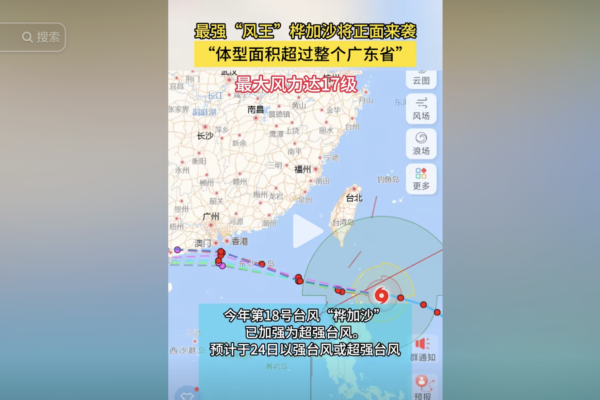
The Beijing Meteorological Center issued a typhoon yellow alert on the morning of September 22nd at 6 am. The center of the super typhoon, named the 18th storm of the year, “Hua Jia Sha,” was located in the northwest Pacific Ocean near Manila, Philippines at about 590 kilometers northwest of North. At 5 am on the 22nd, with a latitude of 19.3 degrees North and longitude of 123.6 degrees East, the typhoon’s center had wind speeds surpassing 17 levels (62 meters per second), a minimum pressure of 910 hPa, a radius of gale-force winds between 340-480 kilometers, and storm-force wind radii ranging from 160-200 kilometers and 80-120 kilometers.
According to the meteorological center’s forecast, “Hua Jia Sha” is expected to move at a speed of around 20 kilometers per hour towards the west after passing through the Bashi Channel on the 22nd. It is projected to enter the northeastern South China Sea on the early morning of the 23rd and then shift towards the west-northwest direction, gradually nearing the coastal areas of central and western Guangdong Province to the northeastern part of Hainan Island.
From 8:00 on the 22nd to 8:00 on the 23rd, the Bashi Channel, northeastern South China Sea, Taiwan Strait, waters east of Taiwan, southwestern East China Sea, Paracel Islands, coastal areas of Fujian, and southeastern coastal areas of Taiwan will experience forceful winds of 7-9 levels, with gusts reaching 10-11 levels. Specifically, some areas in the Bashi Channel and the northeastern South China Sea may encounter winds of 10-13 levels and gusts of 14-15 levels. Wind speeds of 14-17 levels and gusts exceeding 17 levels may occur in areas near the typhoon’s center. From 8:00 on the 22nd to 8:00 on the 23rd, heavy rain is expected in parts of northeastern Fujian and southeastern Zhejiang.
According to the Zhuhai Meteorological Center, “Hua Jia Sha” strengthened into a typhoon on September 20th at 2:00 am, with a size larger than that of the entire Guangdong Province. However, it is forecasted that as it enters the South China Sea, its size will contract, with its energy highly concentrated in the eye of the storm. The latest numerical forecasts indicate that “Hua Jia Sha” has strong development potential and a massive size, bearing similarities to the 2018 Typhoon Mangkhut and the 2023 Typhoon Surah.
The Guangdong Meteorological Department anticipates that on the night of the 22nd, Typhoon “Hua Jia Sha” will enter the South China Sea and head towards the sea area of Guangdong Province, posing severe impacts on both sea and land areas from the 23rd to the 25th.
Several regions in Guangdong have already issued warnings, including possible measures such as school closures, work suspensions, production halts, transportation shutdowns, and business closures in the affected areas.