
Taiwan’s Central Weather Bureau announced on the morning of August 21st that Typhoon Lingling had formed and was predicted to move towards Kyushu, with no direct impact on Taiwan.
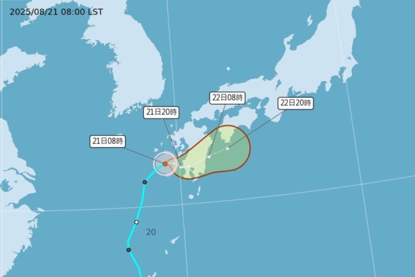
According to the Central Weather Bureau, as of 8 a.m. today, Typhoon Lingling’s center was located at 32.0 degrees north latitude and 129.2 degrees east longitude, moving eastward at a speed of 8 kilometers per hour. The central pressure was 1,002 hectopascals, with maximum sustained winds near the center at 18 meters per second and maximum gusts reaching 25 meters per second. The radius of gale-force winds extended up to 60 kilometers, with 50 kilometers to the northwest, 70 kilometers to the northeast, 50 kilometers to the southwest, and 70 kilometers to the southeast.
Associate Professor Wu Derong of the Department of Atmospheric Sciences at National Central University in Taiwan, stated in the Meteorological Application and Promotion Foundation’s “Sky Machine Classroom” column that the latest European model simulation (ECMWF) indicated a slightly weakening Pacific high-pressure system today. The weather across various regions would remain mostly sunny with some clouds, and temperatures would be hot and humid. Unstable atmospheric conditions could lead to localized showers or thunderstorms in mountainous areas and some plains in the afternoon, with risks of severe weather including lightning, strong winds, and sudden heavy rainfall.
Professor Wu mentioned that according to the latest European model simulation, clear and scorching weather was expected from the 22nd to the 24th, with Taiwan’s highest temperature reaching 38 degrees Celsius. People were advised to take precautions against sunburn and heatstroke. There may be isolated showers or thunderstorms in mountainous areas, with brief rainfall possible in Taitung and Pingtung.
He further explained that from the 25th to the 27th, the weather would remain sunny with some clouds and continued heat in various regions. Increased moisture in the south could lead to sporadic brief showers in Hualien and Pingtung. Unstable atmospheric conditions might result in localized showers or thunderstorms in mountainous areas in the afternoon, requiring vigilance against severe thunderstorms. The latest Weather Bureau “Path Potential Prediction Map” showed a weakening trend of Tropical Depression No. 15 moving eastward towards the western sea area of Kyushu, bringing substantial rainfall to the region.
According to Professor Wu, the latest Global Ensemble Forecast System (GEFS) as of 8 p.m. on the 20th indicated a “tropical disturbance” in the eastern Philippine Sea, moving northwestward to west-northwestward, with the ensemble mean path passing through Luzon Island. Due to the presence of significant vertical wind shears along its path, hindering typhoon development, the latest European ensemble model suggested a weaker scenario with an unclear path. The “tropical disturbance” was assessed to be weak in intensity and on a southerly path, posing no direct threat to Taiwan.