
On August 1st, heavy rainstorms hit multiple provinces in China, leading to urban flooding in cities such as Suzhou in Jiangsu, Datong in Shanxi, and Shantou in Guangdong.
Due to the impact of Typhoon “Zhu Jie Cao,” the water level of Taihu Lake rose to 3.80 meters on August 2 at 4:25 a.m., reaching the alert level. According to monitoring data from the Jiangsu Provincial Department of Water Resources, as of 7 a.m. on August 2, the water level of Taihu Lake was at 3.81 meters, exceeding the alert level by 0.01 meters.
Since July 28, the Ministry of Water Resources has arranged for flood discharge in the Taihu Lake basin, with a total drainage volume of 830 million cubic meters along the Yangtze River and coastal areas.
The Suzhou Meteorological Observatory upgraded the yellow rainstorm warning signal at 7:34 a.m. on August 2, predicting that Suzhou High-Tech Zone, Gusu District, and Suzhou Industrial Park would experience heavy rainfall of over 50 millimeters in an hour within the next 6 hours.
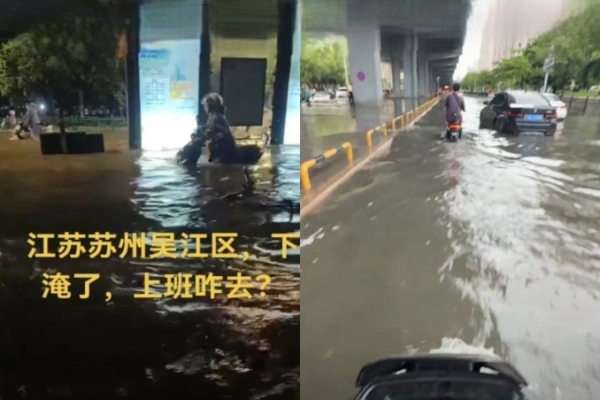
Wujiang District in Suzhou, Jiangsu Province, downstream of Taihu Lake, was submerged due to the combination of heavy rain and flood discharge. Local residents shared videos showing that on the night of August 1st, the town of Tongli in Wujiang District was flooded, with water levels reaching thigh-high in some places. People were seen struggling to navigate the flooded streets with electric scooters, while numerous cars moved slowly through the water.
One netizen mentioned, “Even where you are is considered high ground, our Panghai Road in Wujiang District is even more severely flooded.” They described the challenging situation where even small vehicles couldn’t pass due to water rising to waist level. Partial urban areas in Suzhou were still inundated as of the morning of August 2.
On the evening of August 1, the ancient city of Datong in Shanxi also experienced heavy rainfall. Local residents reported that the rain came down heavily in the city center while sparing the suburban areas.
Videos shared by netizens displayed severe waterlogging in some parts of Pingcheng District in Datong, with road blockages affecting the movement of many vehicles submerged in water.
In the afternoon of August 1, Shantou in Guangdong was hit by intense convective weather, causing significant short-term heavy rain in the central urban area. This led to severe flooding in several locations, with water levels reaching up to 20 centimeters deep, submerging streets and affecting daily life. Local residents expressed their distress, mentioning that their homes were flooded multiple times within just two weeks.
Footage portrayed a scene of flooded streets with vehicles stalled and surrounded by water in the middle of the road.
By 6:30 p.m. on August 1, Kunming also faced extreme weather conditions, with videos showing torrential rain mixed with hail. Many residents expressed fear and caution about navigating the flooded streets due to the heavy rain.
According to the China Meteorological Administration, a yellow rainstorm warning was issued on August 1, predicting heavy to torrential rainfall in central and eastern parts of Anhui, most of Jiangsu, southern and eastern coastal regions of Shandong, and northwestern parts of Zhejiang from 2 p.m. on August 1 to 2 p.m. on August 2.
At 6 a.m. on August 2, a blue warning for severe convective weather was issued by the Central Meteorological Observatory, indicating that some areas in Inner Mongolia, western parts of the Northeast region, central and western parts of North China, eastern Jianghuai Region, and eastern parts of South China are expected to experience thunderstorms with strong wind gusts above 8 on the Beaufort scale or hail. Localized areas in Inner Mongolia, southwestern Heilongjiang, and western Jilin may even encounter wind speeds exceeding 10 on the Beaufort scale, reaching up to 11 or more.
Areas like central and western parts of Heilongjiang, central and western parts of Jilin, northern Tianjin, southeastern Jiangsu, eastern Guangxi, and western Guangdong could experience rainfall exceeding 50 millimeters per hour, with some areas receiving over 70 millimeters. The main impact of severe convective weather is expected to be during the afternoon and evening of today.