
On July 15th (Tuesday), the National Hurricane Center (NHC) in the United States stated that there is a 40% chance that a tropical depression near the east coast of Florida could develop into a cyclone within the next 48 hours.
According to the latest forecast from the National Hurricane Center, a weather system with the code AL93 is expected to move westward through Florida today and tonight, cross the Florida Peninsula, and then reach the northeast part of the Gulf of Mexico by midweek.
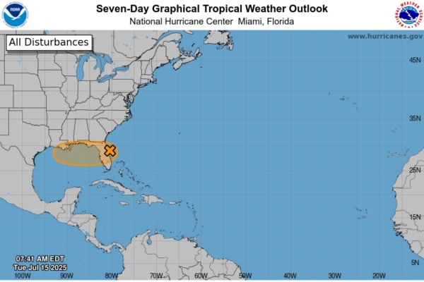
On Tuesday morning, the National Hurricane Center issued reports for the North Atlantic, Caribbean Sea, and the Gulf of Mexico regions:
AL93 is expected to move from the east of the Florida Peninsula into the northeast part of the Gulf of Mexico: Satellite and radar data show that the previously formed low-pressure area over the Atlantic is moving towards the northeast coast of Florida, generating disorganized showers and thunderstorm activity. It is expected that this weather system will move westward through Florida today and reach the northeast part of the Gulf of Mexico by Wednesday.
Overall environmental conditions are favorable for further development of the cyclone, and there is a possibility that a tropical depression may form as this weather system moves through the northeast and central parts of the Gulf of Mexico.
Regardless of the development, the Hurricane Center warns that heavy rainfall may trigger localized flooding in parts of Florida by midweek. Heavy rainfall could also result in flooding in coastal areas in the northeast and central parts of the Gulf of Mexico later this week.
Current data shows:
Probability of formation within 48 hours: 40%.
Probability of formation within 7 days: 40%.
For real-time monitoring of developments, you can visit the official website of the National Hurricane Center (NHC) by clicking here.
Local meteorological news along the Gulf of Mexico coast reports that the low-pressure area near the east coast of Florida has been named “Tropical Storm Dexter,” with the code Invest 93L, and there is a possibility that once this disturbance moves into the Gulf of Mexico, it could develop into Tropical Storm Dexter.
A cyclone is a type of low-pressure system where air rotates and rises towards the center, causing weather phenomena such as winds, rain, storms, and even floods.
The code AL93 stands for:
AL: A stands for the Atlantic Basin, indicating that this weather system is developing in the Atlantic region, including the Gulf of Mexico, the Caribbean Sea, and low-pressure areas near Florida. L is short for “Low,” referring to a low-pressure area.
93 indicates that this is the 93rd disturbance system tracked and observed during the year. Meteorological numbers from 90 to 99 are cyclically used for tracking disturbances.
In the report, AL93 is also referred to as Invest 93L: The term “Invest” implies that the National Hurricane Center (NHC) is monitoring this area for its potential to develop into a tropical cyclone.