
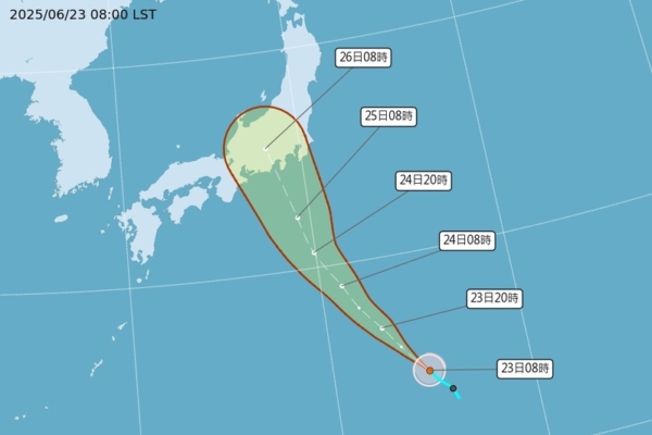
Taiwan’s Central Weather Bureau announced this morning that Typhoon Sepat has formed and is predicted to move towards Japan as a mild typhoon, with no direct impact on Taiwan’s weather.
The Central Weather Bureau reported that at 8 a.m. today, the center of Typhoon Sepat was located at 24.5 degrees north latitude and 144.8 degrees east longitude, moving northwest at a speed of 11 kilometers per hour. With a central pressure of 1002 hectopascals, the maximum wind speed near the center is 18 meters per second, with gusts reaching 25 meters per second. The radius of strong winds around the center extends up to 80 kilometers (80 kilometers on the northwest side, 90 kilometers on the northeast side, 70 kilometers on the southwest side, and 70 kilometers on the southeast side).
The Central Weather Bureau issued a typhoon formation alert this morning: A tropical depression located in the southern sea of Japan developed into a mild typhoon at 8 a.m. today, named Typhoon Sepat (international name: SEPAT). It is forecasted to move northwest towards Japan, with no direct impact on Taiwan’s weather.
In addition, at 11:30 a.m. today, the Central Weather Bureau issued a high temperature advisory: Cloud County, Kaohsiung City, and Pingtung County are under an orange alert, with a likelihood of temperatures reaching 36 degrees Celsius. Residents are advised to take precautions. Taipei City, New Taipei City, Changhua County, Tainan City, and Hualien County are under a yellow alert, signaling the need for caution.