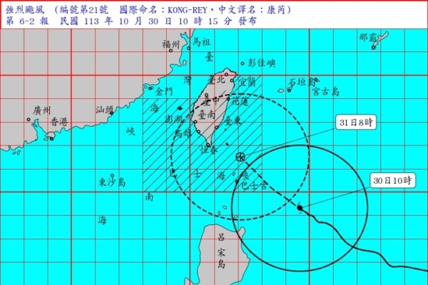
The Central Weather Bureau of Taiwan announced today (October 30) that Typhoon Kong-Rey had intensified into a strong typhoon as of 8 a.m. It is estimated that by tonight, the onshore alert area might encompass the main island of Taiwan.
At 10:15 a.m. today, the Central Weather Bureau issued a marine and land typhoon warning. The center of Typhoon Kong-Rey (internationally named KONG-REY) was located at 19.3 degrees north latitude, 124.6 degrees east longitude at 10 a.m., about 480 kilometers southeast of Eluanbi, moving towards the northwest at a speed of 15 to 20 kilometers per hour.
“The 21st typhoon, Kong-Rey, has intensified into a strong typhoon,” the Central Weather Bureau stated. According to the latest data, the center is currently in the southeast sea area near Eluanbi, moving northwest, with its storm circle gradually entering the Bashi Channel, posing a threat to Hualien, Taitung, Pingtung, and the Hengchun Peninsula.
The Central Weather Bureau announced the onshore alert areas: Hualien, Taitung, Pingtung, and the Hengchun Peninsula should be on high alert. The marine alert areas include the Taiwan Strait, the eastern waters of Taiwan, the Bashi Channel, and the Dongsha Islands waters, where maritime vessels should exercise caution.
The Central Weather Bureau mentioned that coastal areas of Taiwan, including Lanyu, Green Island, Penghu, Kinmen, and Matsu, are prone to high waves. The sea conditions and wind waves are expected to gradually increase, with waves exceeding 3 to 5 meters, especially with waves over 6 meters in the eastern and southeastern coastal areas and Lanyu. People are advised to avoid seaside activities.
A special report on strong winds on land: due to the peripheral circulation of the typhoon, on the 30th, Lanyu, Green Island, and Penghu will experience strong gusts of 11 to 12 levels, while Taoyuan to Yunlin and the open coastal areas in the southeast, the Hengchun Peninsula, and Matsu will encounter gusts of 9 to 10 levels. Other open coastal areas and Kinmen will also experience strong gusts. From midnight on the 29th to 10 a.m. on the 30th, Taipei’s Qingshan Gang received 230 millimeters of rainfall.
Forecaster Zhu Meilin of the Central Weather Bureau stated during a press conference that Typhoon Kong-Rey had intensified into a strong typhoon at 8 a.m. today and is expected to move towards the southeast waters of Taiwan. With Kong-Rey approaching, the onshore alert area may cover the entire island of Taiwan tonight, with maritime waves gradually increasing. As Kong-Rey’s peripheral circulation affects Taiwan and moves closer, rainfall will intensify in the north, Yilan, and Hualien this afternoon, with increased rainfall expected in central and southern areas after the typhoon makes landfall.
Zhu Meilin mentioned that Typhoon Kong-Rey continues to move northwest, with its speed gradually increasing. By around noon to evening on October 31, there is a chance of the eyewall making landfall south of Hualien. It is predicted that by the evening of October 31, the center of the typhoon will enter the Taiwan Strait. She stated that from the night of October 31 to the early morning of November 1 will be the period when the impact of the typhoon on Taiwan is most significant.
Associate Professor Wu Derong of the Department of Atmospheric Sciences at National Central University mentioned on “Sanlih Weather Watch – Secrets of the Weather” that as of 2 a.m. on the 30th, the latest official forecast paths from various countries show that Typhoon Kong-Rey is likely to make landfall in the vicinity of Taitung County. The latest European model (ECMWF) as of 8 p.m. on the 29th suggests that the landing point for Typhoon Kong-Rey lies roughly in Taitung County. Observing the Meteorological Administration’s “Path Potential Prediction Map,” the range of uncertainty has narrowed but still includes Taiwan’s land and adjacent waters.
Wu Derong mentioned that individual ensemble simulation paths from the European model almost all indicate landfall in Taiwan. The implications of both models suggest that the probability of Typhoon Kong-Rey making landfall in Taitung County is highest, but slight deviations south or north are also possible. In addition, satellite data shows that Typhoon Kong-Rey is a “large-eyed typhoon,” with a wider eye wall passage range, posing a severe threat of “destructive winds” near the landing point (Taitung and surrounding counties and cities).
Wu Derong pointed out that the latest European model simulations indicate that due to the northeastern monsoon and the influence of the peripheral circulation of Typhoon Kong-Rey, prolonged rainfall and increased rainfall are expected in the northern and northeastern regions today. Showers are expected in Hualien and Taitung, while the back windward areas in central and southern regions will experience partly cloudy skies. On October 31 and November 1, Typhoon Kong-Rey will bring strong winds and heavy rain, warranting vigilance across various regions. Mountainous areas can expect total rainfall amounts of up to 1,200 millimeters. The threat posed by the “destructive winds” accompanying the eyewall should not be underestimated. Detailed wind and rainfall information for various areas should be monitored through the rolling alerts issued by the Meteorological Bureau.

