
Taiwanese meteorological experts today (24th) stated that the outer circulation of Typhoon Tangmei is affected by terrain uplift, with a high probability of heavy rainfall in the northern and eastern parts facing the wind. Caution is advised for possible rain-induced disasters on the windward side on the 24th and 25th, with coastal areas needing to be vigilant against strong winds.
The Central Weather Bureau of Taiwan issued a heavy rain warning on Facebook today, citing the influence of the northeast monsoon and the outer circulation of the typhoon, leading to short-duration heavy rainfall. There will be localized heavy or very heavy rain in the coastal areas of New Taipei City, mountainous areas of Taipei City, and Yilan County today. Keelung City and mountainous areas of New Taipei City may experience localized heavy or heavy rain. There is a chance of localized heavy rain in Greater Taipei, Yilan region, Green Island, and Orchid Island. Mountainous areas should be cautious of landslides and rockfall, while low-lying areas need to guard against flooding. Areas expecting very heavy rain: Taipei City, New Taipei City, Yilan County.
Wu Derong, Associate Professor at the Department of Atmospheric Sciences of National Central University of Taiwan, mentioned in the program “Sanli Weather: The Secrets of Weather Prediction” that the latest European model (ECMWF) simulation at 8 p.m. on the 23rd shows that the outer circulation of Typhoon Tangmei is influenced by terrain uplift, indicating a high probability of heavy rainfall in the northern and eastern parts facing the wind. Strong winds are expected along the coast, and close attention should be paid to the special warnings issued by the weather bureau. The flatlands on the lee side are less affected due to the barrier of the Central Mountain Range, but there can still be localized heavy rain in mountainous areas.
Wu stated that it is significantly cooler in the northern and eastern parts, with a slight drop in temperature in other regions. Temperatures range from 18 to 24 degrees Celsius in the north, 19 to 31 degrees in the central region, 20 to 32 degrees in the south, and 19 to 29 degrees in the east. On the 25th, the northern mountainous areas and eastern parts will continue to experience a high probability of heavy rainfall due to the influence of the outer circulation of Typhoon Tangmei. Attention should be paid to the special warnings issued by the weather bureau. The flatlands on the lee side will see less impact, while mountainous areas may still experience localized heavy rainfall; temperatures will rise significantly during the day.
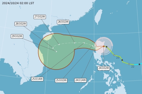
Regarding the future movements of Typhoon Tangmei, Wu stated that according to the Central Weather Bureau’s “Potential Impact Forecast” chart, the center of Typhoon Tangmei passed through Luzon Island and entered the South China Sea by 2 a.m. on the 25th. From the 27th to the 29th, it will be in the southeast waters of Hainan Island, slowing down and starting to turn, with a significantly expanded uncertain range due to the approach of another typhoon, causing mutual influence known as the “twin typhoon effect.”
Wu explained that the latest European (ECMWF) model ensemble simulation chart at 8 p.m. on the 23rd indicates that the average path of the ensemble for the first five days is similar to the “Potential Impact Forecast” chart. However, after five days, individual simulation paths show a nearly “spiral” distribution, leading to a significant level of uncertainty in the ensemble average path. Therefore, it should not be relied upon for inferences, and continuous observation is recommended.