
Taiwan meteorological experts say that the tropical storm “Beibi Jia” is expected to strengthen into a typhoon tonight (September 12) and is projected to move towards the Japanese Ryukyu Islands, with a landfall expected in Zhejiang, China on the 16th, while the probability of it affecting Taiwan is low.
The Central Weather Bureau of Taiwan reported that the center of the typhoon “Beibi Jia” was located at 17.5 degrees north latitude, 139.8 degrees east longitude at 8 a.m. today, moving at a speed of 21 kilometers per hour in a north-northwest direction. The central pressure is 980 hectopascals, with maximum sustained winds near the center at 28 meters per second and maximum gusts at 35 meters per second. The radius of strong winds extending outward from the center is 120 kilometers (80 kilometers to the northwest, 160 kilometers to the northeast, 80 kilometers to the southwest, and 150 kilometers to the southeast).
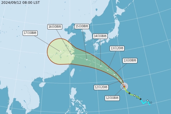
Associate Professor Wu Derong from the Department of Atmospheric Sciences at National Central University in Taiwan, speaking on “Sanli Zhun Weather Insights,” stated that the Central Weather Bureau’s “Path Potential Prediction Chart showed that the tropical storm Beibi Jia is forecasted to strengthen into a typhoon tonight, and is expected to move northwest towards the Japanese Ryukyu Islands, enter the East China Sea on the 15th, and make landfall in Zhejiang on the 16th, with a low probability of affecting Taiwan.”
Wu Derong mentioned that the latest (as of 8 p.m. on the 11th) European model (ECMWF) ensemble predicted paths of 50 simulations show that the average path is similar to that forecasted by the Central Weather Bureau, but some paths are very close to Taiwan, so close monitoring is still necessary. According to the latest European model simulations, by 8 p.m. on the 17th, Typhoon “Beibi Jia” is already in central China, with another disturbance developing in the eastern Philippine Sea, both far away from Taiwan and having no direct impact on Taiwan’s weather. The future trajectory of these systems remains uncertain and requires further observation as different models show varying results.
Wu Derong further added that the latest (as of 8 p.m. on the 11th) European model simulations indicate that moisture is moving into the eastern side of Taiwan today, resulting in localized rainfall in the northern and eastern regions. Unstable atmospheric conditions may lead to strong convective activities in the central and southern regions in the afternoon, with a high chance of thunderstorms. On the 13th and 14th, moisture will decrease slightly, with occasional brief showers in the north and east and localized afternoon showers or thunderstorms in the mountainous regions of central and southern Taiwan. The temperature across different regions today ranges from 22°C to 36°C in the north, 24°C to 36°C in the central region, 24°C to 36°C in the south, and 22°C to 35°C in the east.
As per the latest model projections, on the 15th and 16th, Typhoon “Beibi Jia” is expected to cross the East China Sea and make landfall in Zhejiang. The northern region may experience localized showers, occasional brief afternoon showers in the mountainous areas, a slight temperature drop on the 15th, followed by a temperature rise on the 16th. On the 17th and 18th, moisture will continue to move into the eastern side of Taiwan, with mostly cloudy skies in the greater Taipei area and the eastern region, occasional brief showers, partly cloudy skies in the western region and localized afternoon showers in the mountainous areas.