
Arctic cold air swept through most of the United States on Monday, bringing snow to some areas and causing a massive drop in temperatures across two-thirds of the eastern United States. The Great Lakes region saw snow accumulation exceeding 1 foot, while Florida, which just experienced temperatures near 80 degrees Fahrenheit the day before, is now facing record-breaking extreme cold.
Intense lake-effect snow is causing hazardous travel conditions in the Great Lakes region. This narrow band of snow is leading to significant differences in snowfall amounts:
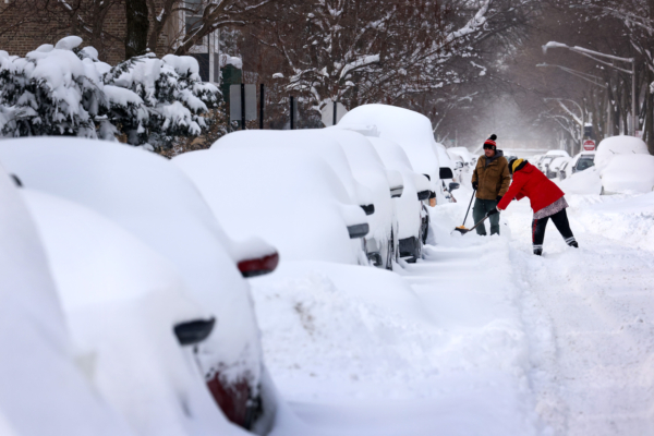
In the Chicago area, snow accompanied by thunder and strong winds fell overnight, with Cook County, where downtown Chicago is located, still experiencing noticeable snow accumulation despite a downgrade in winter storm warnings.
South of Chicago by over 50 miles, snowfall has reached 1 foot; parts of northwest Indiana have seen up to 10 inches of snow accumulation.
In Lake County, Illinois, snow accumulation has reached 6 inches in some areas.
The National Weather Service (NWS) issued warnings for dangerous travel conditions along I-57 interstate highway in Kankakee and Iroquois counties due to snow and strong winds.
The snow threat is expanding across the entire Great Lakes region. Snow accumulation in the upper half of Michigan has exceeded 1 foot. Snowbelt areas in the eastern Great Lakes region (northeastern Ohio, northwestern Pennsylvania, and southwestern New York) are expected to continue accumulating several inches of snow until Tuesday.
The Arctic blast is bringing a widespread impact on temperatures, with tens of millions experiencing their coldest morning since spring. Tuesday’s temperatures are expected to drop even further:
Ohio, West Virginia, and Kentucky have issued cold weather alerts. A large portion of the southern United States, stretching from Texas and Oklahoma to Alabama and Georgia, is expected to see subfreezing temperatures throughout Monday morning.
Temperatures may drop to or below freezing, posing a threat even to Florida. Meteorologists indicate that the wind chill index in the state may reach around 30 degrees Fahrenheit.
Washington, D.C., and New York City will experience the coldest mornings on Tuesday. Temperatures in Washington, D.C., may drop to 30 degrees Fahrenheit, while the wind chill temperatures in New York City could be around 20 degrees Fahrenheit.
Several inches of snow are expected on Monday in the western slopes of the central Appalachian Mountains and in high-altitude areas from West Virginia to the Tennessee border.
Meteorologists have issued special guidelines to gardening enthusiasts, emphasizing that frost alerts signal the end of the growing season. Meteorologists in Arkansas warn, “Take immediate steps to protect delicate plants from the cold.”
However, the good news is that this cold snap will not last long. Temperatures in the central United States will rapidly rise on Tuesday, and most of the eastern United States will warm up again by Wednesday.
(This article referenced reports from CNN and the Associated Press)